If the page does not refresh automatically, you may need to refresh your browser to see the latest data.
All times are in Eastern Standard Time (EST).
 Weather Observations at NWS Marquette Weather Observations at NWS Marquette |
| Current Observation |
| 5/18/24 10:55pm EST |
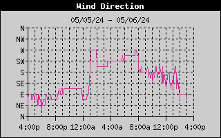
| Temperature: | 68.5°F | Wind Direction: | SSW |  |
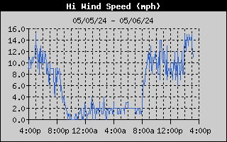
| Wind Chill: | 65.9°F | Wind Speed: | 11 mph |
| Dew Point: | 58.3°F | Wind Gust: | 22 mph |
| Relative Humidity: | 70% |
| Barometric Pressure: | 29.66 inches |
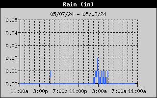
| Rainfall: | 15min: 0.00" | 1hr: 0.00" | 3hr: 0.00" | 24hr: 0.00" |
Today (since Midnight EST)
|
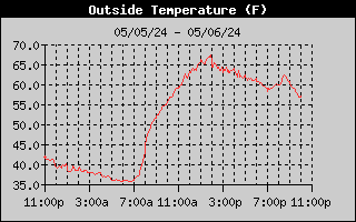
| Maximum Temperature: | 82.6°F at 3:10pm | Rainfall: | 0.00 inches |
Minimum Temperature:
| 56.4°F at 2:55am
| Max Instant Rain Rate:
| 0.00 in/hr at 12:00am
|
| Maximum Wind Chill: | 82.6°F at 3:10pm | Maximum Wind Gust: | 30 mph at 6:05pm |
Minimum Wind Chill:
| 55.6°F at 3:15am
| Max Wind Gust Direction:
| SSE
|
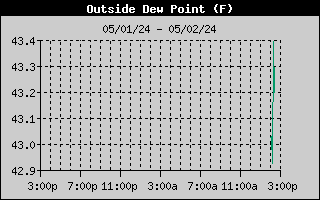
| Maximum Dew Point: | 58.4°F at 10:45pm | Max Barometric Pressure: | 29.76 inches |
Minimum Dew Point:
| 49.0°F at 5:30am
| Min Barometric Pressure:
| 29.63 inches
|
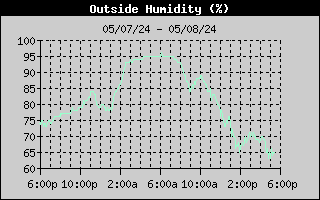
| Maximum Relative Humidity: | 80% at 12:20am |
| Minimum Relative Humidity: | 34% at 3:10pm |
|
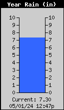
Monthly Total
|
Yearly Total
|
|
Note: Does not include liquid-equivalent from frozen precipitation.
|
 |
 |
The data on this page is obtained from a Davis Weather Station located at the NWS Marquette Weather Forecast Office in Negaunee Township. This data is unofficial and is provided for general informational purposes only.


 Follow us on YouTube