Alexis Howe
Baltic High School, Baltic, SD
Philip Schumacher
National Weather Service, Sioux Falls, SD
Snowstorms with snowfall greater than 10 inches, while uncommon, do occur in the Sioux Falls area. The most recent event occurred from December 23-26, 2009, when Sioux Falls received 19 inches. Since records began in the late 19th century, there have been 33 events in which at least 10 inches of snow fell in 24 hours or less. A list of those events can be found here. The heaviest snowfall occurred from February 16-18, 1962, when 32.2 inches of snow was recorded by the National Weather Service.
In order to better understand weather patterns that are common to heavy snowfall events, meteorologists will average different fields, such as surface temperature. By looking at average fields, meteorologists can identify common features which may occur with an event such as heavy snowfall. So, in order to better understand the common features associated with heavy snowfall in the Sioux Falls area, we have taken an average of the surface temperature, 5000 ft (850 mb) winds, and the mean sea level pressure for the Top 20 heaviest snowfalls in Sioux Falls since 1953. By entering the dates of when snow began to fall, the time when snow was heaviest and when the snow ended, we can see how significant features change during a snowstorm in the Sioux Falls area. Images were provided by the NOAA/ESRL Physical Sciences Division, Boulder, Colorado, via their Web site at https://www.esrl.noaa.gov/psd/.
Beginning of the snow storm
The maps below are the average mean sea level pressure, 5000 ft (850 mb) winds and surface temperatures when snow began in the Sioux Falls area.
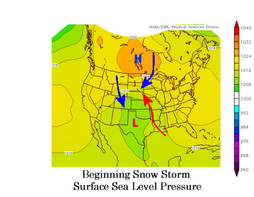
As snow begins to fall in Sioux Falls, low pressure has begun to develop over Texas. Ahead of the low, warm and moist air over the Gulf of Mexico begins to flow northward into the Central Plains. Meanwhile, high pressure is centered over the Canadian prairies. This keeps a northeasterly wind over the Northern Plains, including Sioux Falls. This cool and dry air flowing southward ensures that the air over southeast South Dakota remains below freezing and that the precipitation will most likely be snow.
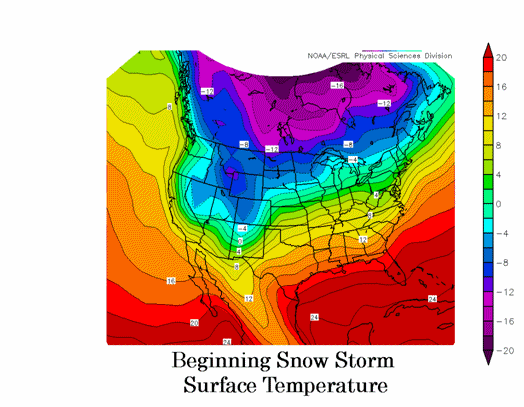
Surface temperatures as snow begins in Sioux Falls average around -4 degrees Celsius or 25 degrees Fahrenheit. Note that the temperatures over southern Canada are colder than -10 degrees Celsius (14 degrees Fahrenheit). This is the source of the cold air moving into the Northern Plains, which prevents temperatures from rising above freezing at the surface.
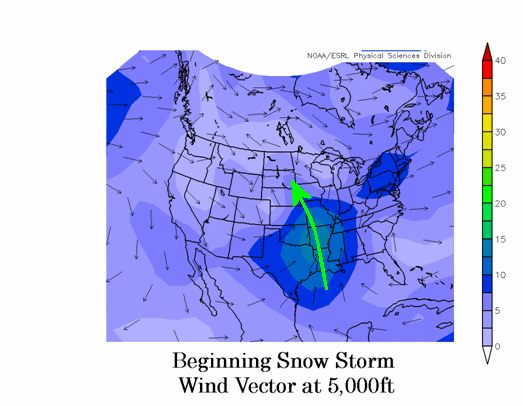
At 5000 ft above the surface (850 mb), southerly wind flow has developed ahead of the low pressure over Texas. This is bringing warm and moist air northward into the Northern Plains. Because of the cold air at the surface, the warm and moist air is forced upward in the atmosphere, resulting in the formation of clouds and snow.
Middle of the snowstorm
The maps below represent the average conditions in the middle of the snowstorm.
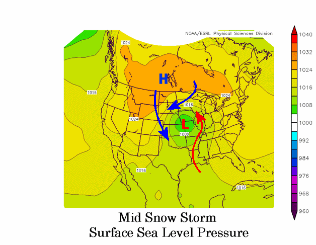
As the storm continues in Sioux Falls, the surface low pressure strengthens and moves to the northeast. Note that the track of the low remains south of Sioux Falls - generally going from Texas to the Kansas City area. Warm and moist air continues to move northward from the Gulf of Mexico into the Upper Midwest. With high pressure remaining centered over southern Canada, however, this warm air is unable to get into eastern South Dakota. Instead, east or northeast winds continue to bring cold Canadian air into the Sioux Falls area. As the low begins to move east, strong northwest winds will also begin develop over the Western Plains. This is the beginning of much colder air which will move south into the northern United States behind the low pressure system. In addition, as the low pressure area intensifies, the pressure gradient between the high in Canada and low near Kansas City increases, resulting in stronger winds over eastern South Dakota. This can create blowing snow and even blizzard conditions with the strongest storms.
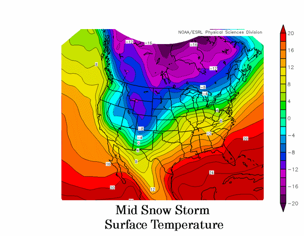
One can see the effect of the wind field around the low and high pressure systems over the Plains. Temperatures have warmed above freezing (0 degrees Celsius) over the Great Lakes, while temperatures have begun to cool (less the -8 degrees Celsius or 18 degrees Fahrenheit) over western South Dakota and North Dakota. Over the Sioux Falls area, temperatures remain around -4 degrees Celsius (25 degrees Fahrenheit).

The stronger winds can also be found at 850 mb, where winds greater than 20 m/s (40 mph) are seen over portions of Missouri and Illinois. As warm and moist air flows north toward the Great Lakes, it gradually turns toward the west into eastern South Dakota. This warm and moist air is forced to rise as it approaches the Dakotas, resulting in the continued development of heavy snow.
End of the snowstorm
The maps below represent the average conditions as the snowfall ends over Sioux Falls.
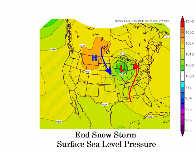
As the snow ends in Sioux Falls, the low pressure has moved into Wisconsin. Warm air and moisture continue to flow north into the eastern Great Lakes, but it is no longer able to get back into the Dakotas. Instead, high pressure begins to move southward into the Northern Rockies. As a result, strong northwest winds develop across the eastern Dakotas and bring colder air into the area. In addition, this wind can bring blowing snow, dangerous wind chills, and even ground blizzard conditions to the region.
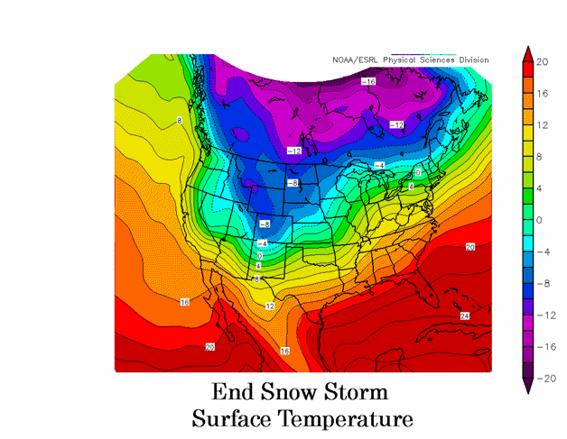
With the low moving off to the east, the temperatures begin to slowly cool across the area. The average temperature is Sioux Falls is around -5 degrees Celsius (23 degrees Fahrenheit) at this point. However, with temperatures less than -10 degrees Celsius (14 degrees Fahrenheit) still located along the Canadian border, much colder temperatures typically move into the area following the end of snowfall over the region.
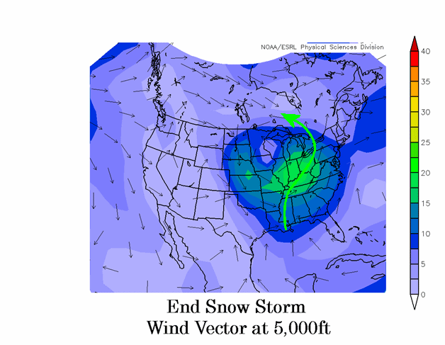
The warm and moist air at 5000 ft (850 mb) flows into the eastern Great Lakes and southern Canada. Strong northerly flow has developed over the eastern Dakotas, with winds at 5000 ft reaching speeds greater than 15 m/s (30 mph). This begins to dry out the atmosphere and end the snowfall. In many cases, these strong winds will also reach the surface producing blowing snow.


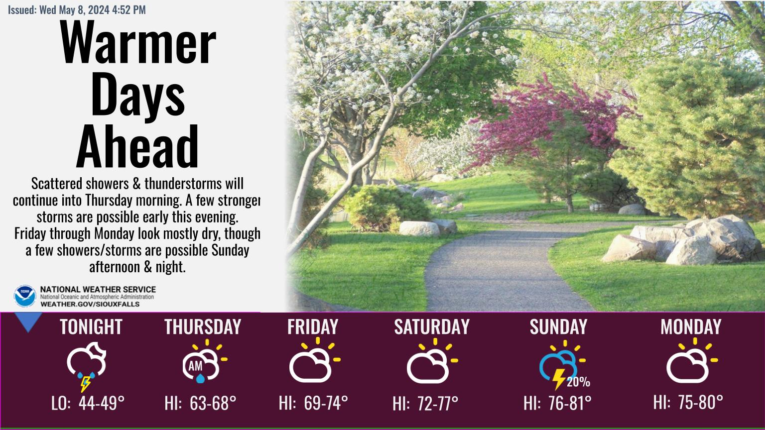 Weather Story
 Weather Map
 Local Radar
 Follow us on YouTube