Overview
|
A multi-faceted storm system moved across the region June 8-9, 2020, producing 2 rounds of severe weather in different locations, as well as areas of heavy rainfall. The prolonged nature of this event was driven by Tropical Depression Cristobal, which lifted north along the Mississippi River Valley on these 2 days, before becoming extra-tropical and turned northeast into the Great Lakes. While our area did not experience rainfall directly associated with Cristobal, this south-north moving tropical system blocked the weather pattern from progressing, resulting in several hours of storms tracking through areas west of Interstate 29 from the evening of June 8 through the afternoon of June 9. By late in the day on June 9, the remnants of the tropical system has begun to weaken, allowing stronger storms and locally heavy rainfall to work eastward into far southeast South Dakota and northwest Iowa. |
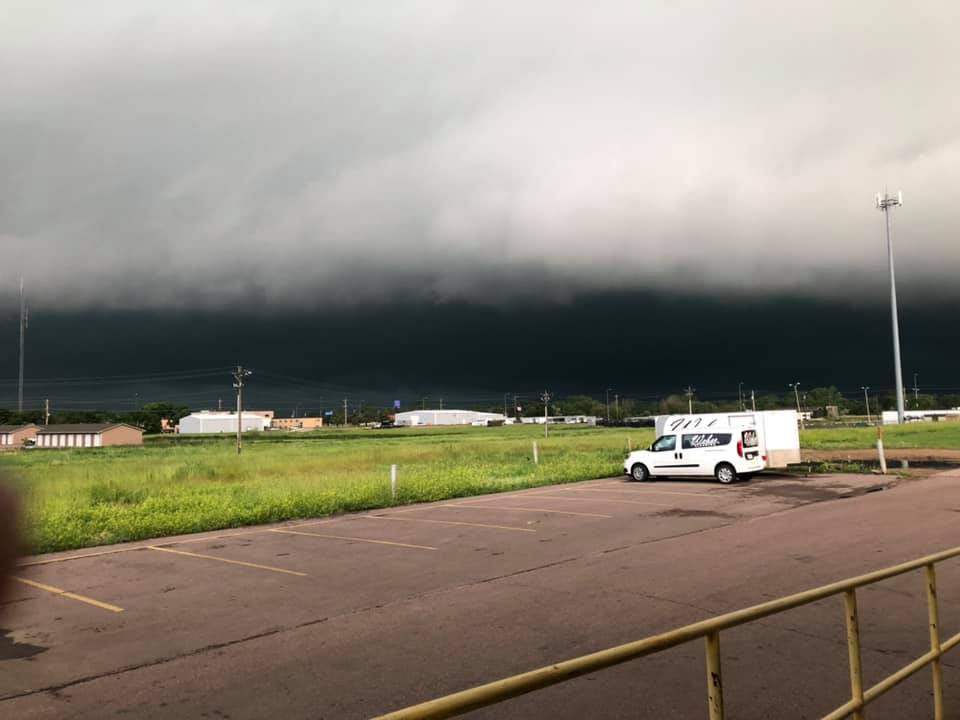
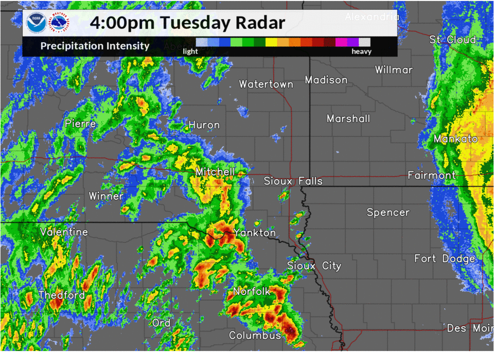
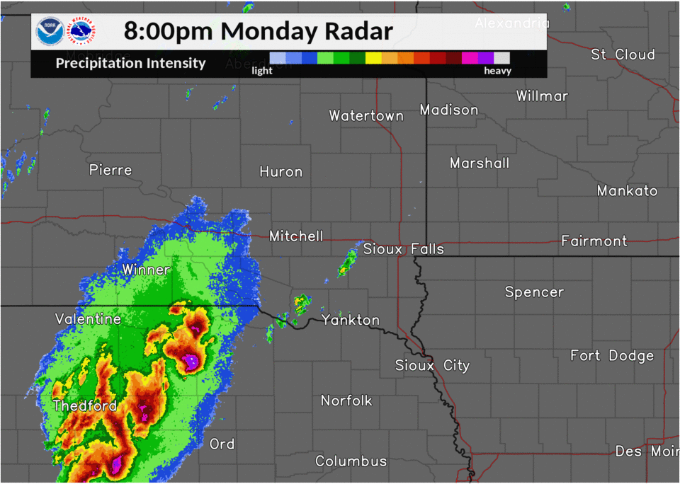 Severe Thunderstorm Radar Imagery - Monday Night 6/8/2020 |
Wind & Hail:
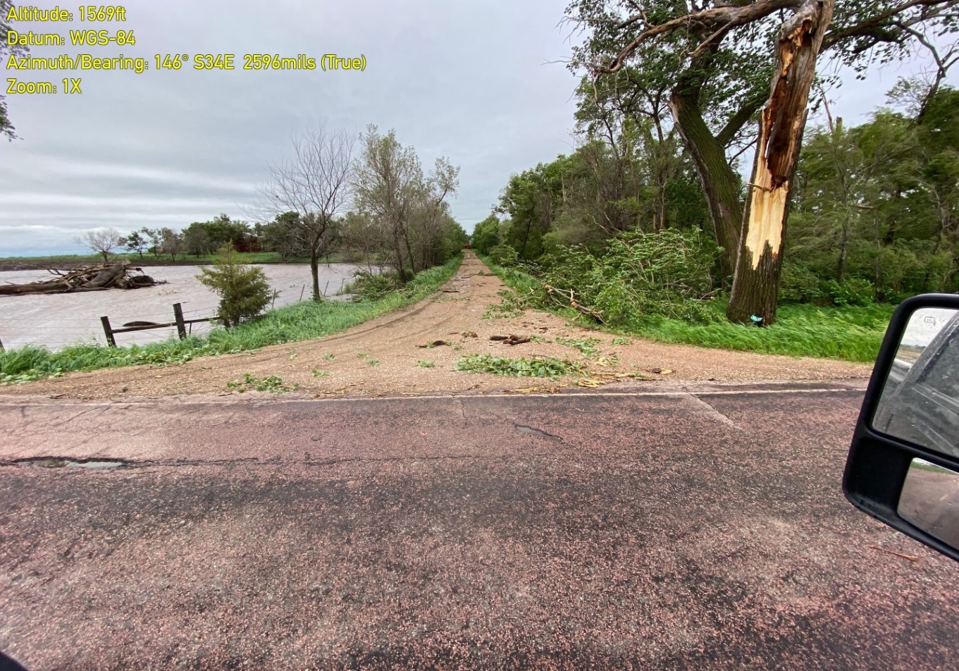
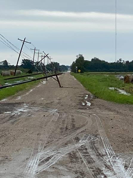
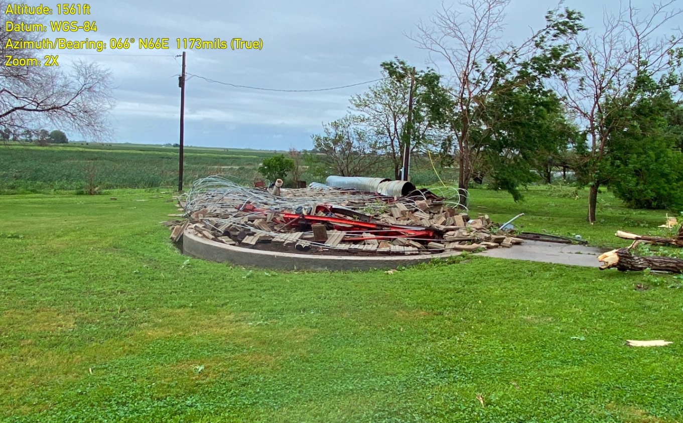
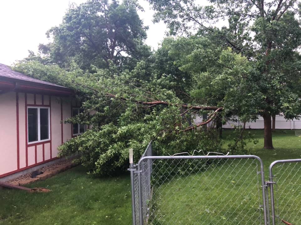
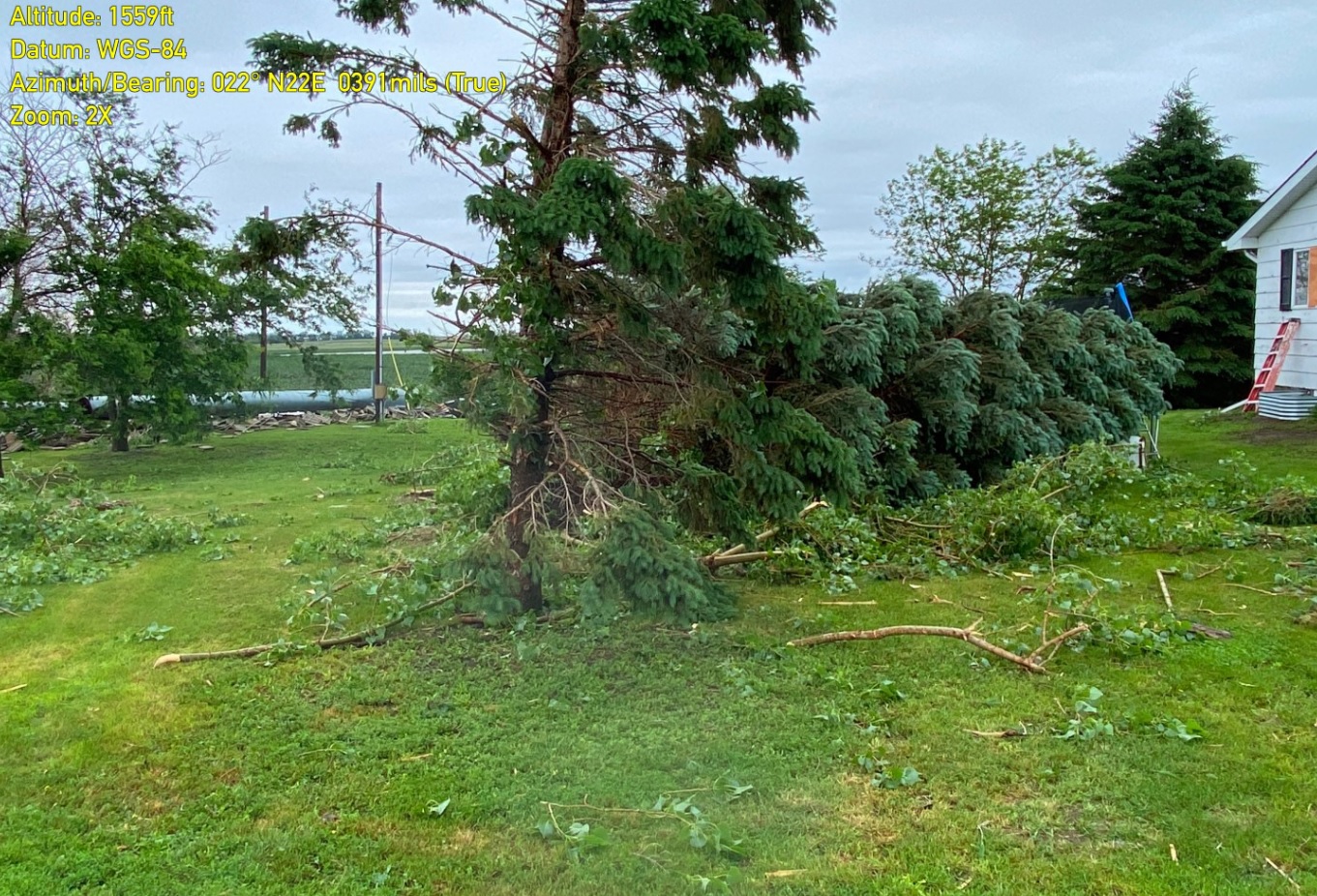
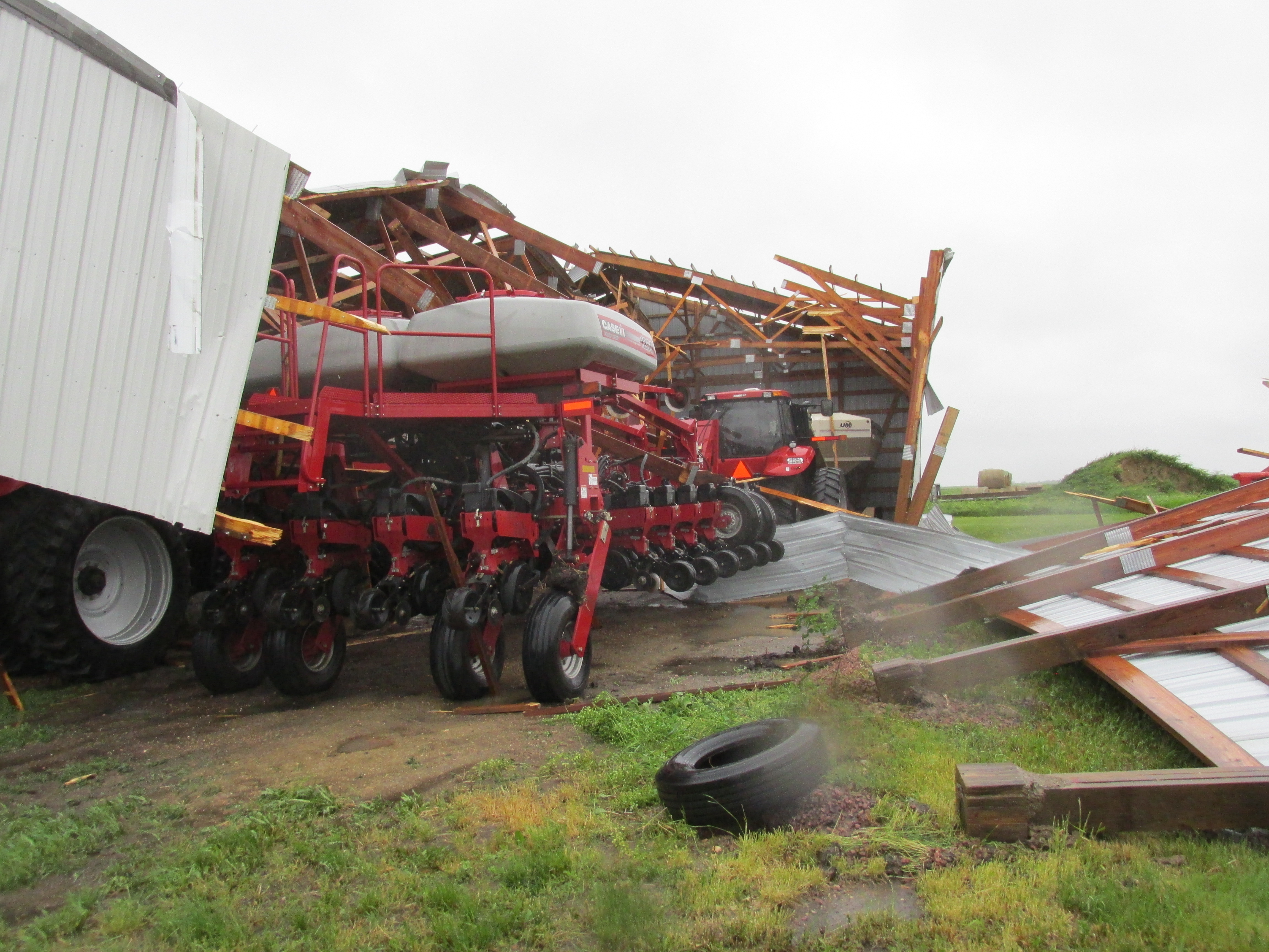
Strong winds damaged many trees, power lines, and out-buildings across the area. The largest hail was tennis-ball sized with the strong storms on Monday evening, June 8th.
Wind
Insert summary here.
 |
 |
 |
 |
| near Corsica, SD - Douglas County Emergency Management | near Mt Vernon - Davison County Emergency Management | near Corsica, SD - Douglas County Emergency Management | Mitchell, SD - Dani H |
Hail
Insert summary here.
 |
 |
||
| Wagner, SD - Matt W | Wagner, SD - Rachel W | Caption | Caption |
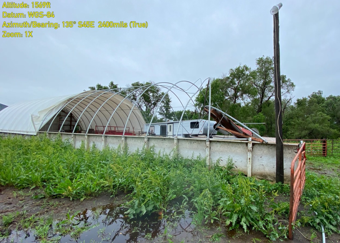
Photos & Video
Header
 |
 |
 |
 |
| near Corsica, SD - Douglas County Emergency Managemnt | Mitchell, SD - Dan S | Mitchell, SD - Chuck K | near Stickney, SD - Aurora County Emergency Management |
Header
 |
 |
 |
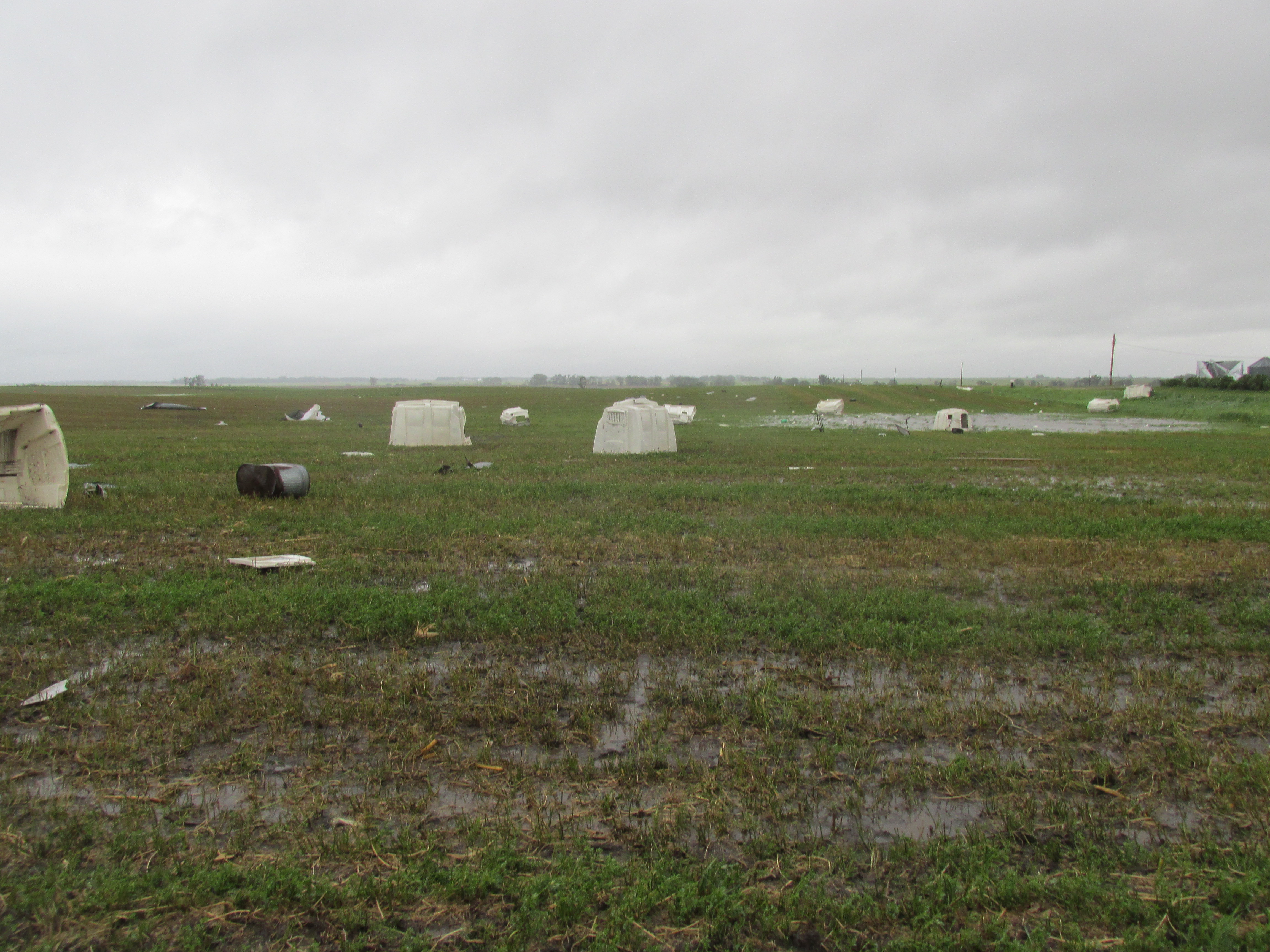 |
| near Corsica, SD - Douglas County Emergency Managemnt | Mitchell, SD - Dani H | near Mt Vernon - Davison County Emergency Management | near Stickney, SD - Aurora County Emergency Management |
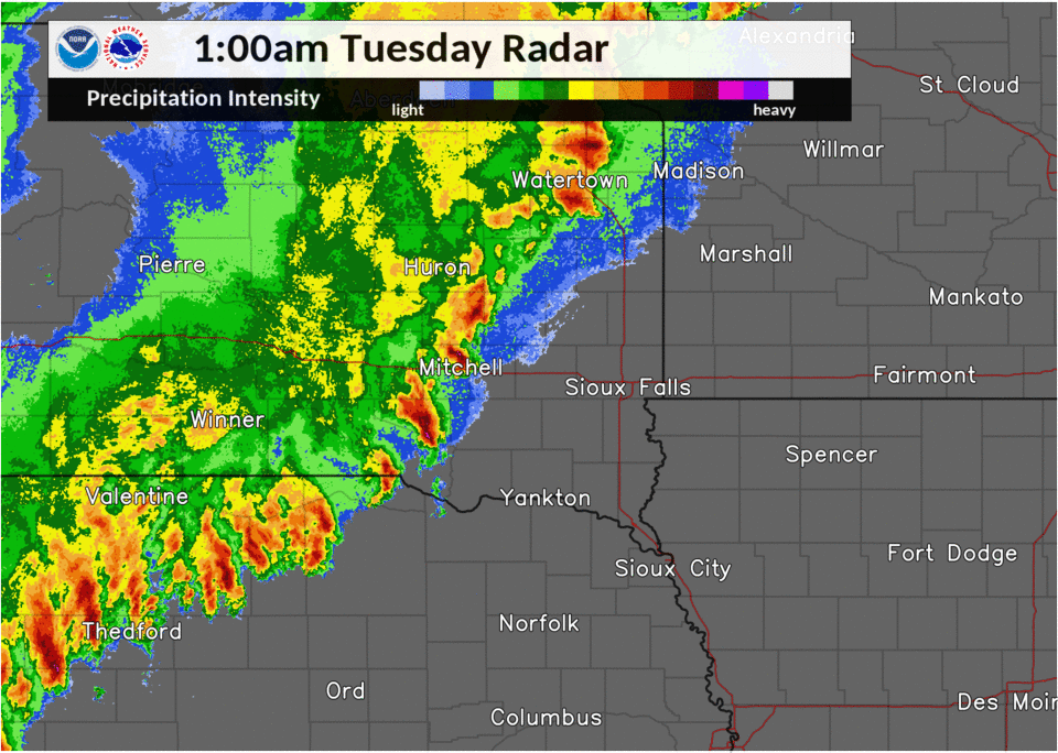
Radar
Header
|
 |
 |
|
| Monday 6/8/20 7pm - Tuesday 6/9/20 1am | Tuesday 6/8/20 1am - Tuesday 6/9/20 7am | Tuesday 6/8/20 4pm - Tuesday 6/9/20 10pm | Caption |
Header
| Caption | Caption | Caption | Caption |
Storm Reports
PRELIMINARY LOCAL STORM REPORT...SUMMARY
NATIONAL WEATHER SERVICE SIOUX FALLS SD
231 PM CDT THU JUN 11 2020

..TIME...   ...EVENT...      ...CITY LOCATION...     ...LAT.LON...
..DATE...   ....MAG....      ..COUNTY LOCATION..ST.. ...SOURCE....
            ..REMARKS..

0622 PM     TSTM WND GST     DAVIS                   43.26N 97.00W
06/09/2020  M58 MPH          TURNER             SD   MESONET

            .

1040 PM     TSTM WND GST     1 NW PARKSTON           43.40N 97.99W
06/08/2020  E50 MPH          HUTCHINSON         SD   PUBLIC

            NO LARGE HAIL SEEN AT TIME OF STRONG WINDS.

0720 PM     TSTM WND GST     2 NE SIBLEY             43.42N 95.72W
06/09/2020  M57 MPH          OSCEOLA            IA   MESONET

            .

0803 PM     TSTM WND GST     SPENCER                 43.15N 95.15W
06/09/2020  M63 MPH          CLAY               IA   ASOS

            .

0735 PM     TSTM WND GST     CHEROKEE                42.75N 95.55W
06/09/2020  M53 MPH          CHEROKEE           IA   AWOS

            .

0615 PM     TSTM WND GST     2 S CHANCELLOR          43.34N 96.99W
06/09/2020  M80 MPH          TURNER             SD   TRAINED SPOTTER

            REPORT VIA SOCIAL MEDIA.

0635 AM     TSTM WND GST     4 ESE FORESTBURG        44.01N 98.03W
06/09/2020  M51 MPH          SANBORN            SD   MESONET


1155 PM     TSTM WND GST     5 SSE CANOVA            43.81N 97.48W
06/08/2020  M56 MPH          MCCOOK             SD   PUBLIC


1015 PM     TSTM WND GST     3 S MITCHELL            43.69N 98.03W
06/08/2020  E55 MPH          DAVISON            SD   PUBLIC

            REPORT VIA SOCIAL MEDIA. DIME SIZE HAIL ALSO
            REPORTED.

0539 AM     TSTM WND GST     1 WSW PLANKINTON        43.71N 98.51W
06/09/2020  M59 MPH          AURORA             SD   MESONET


0554 PM     TSTM WND GST     ROCK VALLEY             43.20N 96.30W
06/09/2020  E50 MPH          SIOUX              IA   TRAINED SPOTTER

            9 INCH DIAMETER PARTIALLY ROTTEN TREE LIMB
            DOWN.

0803 PM     TSTM WND GST     SPENCER                 43.15N 95.15W
06/09/2020  M72 MPH          CLAY               IA   ASOS

            CORRECTS PREVIOUS TSTM WND GST REPORT FROM
            SPENCER.

0740 PM     TSTM WND GST     3 WNW EVERLY            43.18N 95.38W
06/09/2020  E50 MPH          CLAY               IA   CO-OP OBSERVER


0552 PM     TSTM WND DMG     2 WSW HURLEY            43.26N 97.13W
06/09/2020                   TURNER             SD   PUBLIC

            REPORT VIA SOCIAL MEDIA. SEMI-TRUCK TURNED
            OVER ONTO ITS SIDE.

0552 PM     TSTM WND DMG     4 S PARKER              43.34N 97.15W
06/09/2020                   TURNER             SD   EMERGENCY MNGR

            SEVERAL TREES UPROOTED AROUND TOWN.

0540 PM     TSTM WND DMG     2 NW VIBORG             43.19N 97.11W
06/09/2020                   TURNER             SD   EMERGENCY MNGR

            GRAIN BIN WAS KNOCKED OFF BASE AND FLIPPED
            OVER.

0935 PM     TSTM WND DMG     3 S SIOUX FALLS         43.51N 96.72W
06/09/2020                   MINNEHAHA          SD   PUBLIC

            REPORT FROM MPING: 1-INCH TREE LIMBS BROKEN;
            SHINGLES BLOWN OFF.

0645 PM     TSTM WND DMG     2 SSW WORTHING          43.30N 96.78W
06/09/2020                   LINCOLN            SD   BROADCAST MEDIA

            SEMI-TRUCK AND TRAILER TIPPED OVER AND ALSO
            A COUPLE OF VEHICLES DAMAGED.

0633 PM     TSTM WND DMG     WORTHING                43.33N 96.77W
06/09/2020                   LINCOLN            SD   PUBLIC

            REPORT FROM MPING: 3-INCH TREE LIMBS BROKEN;
            POWER POLES BROKEN.

0536 AM     TSTM WND DMG     4 NE HARRISON           43.47N 98.46W
06/09/2020                   DOUGLAS            SD   EMERGENCY MNGR

            CONCRETE SILO TOPPLED, UPROOTED TREES, AND
            BROKEN WINDOW ON HOUSE. TIME ESTIMATED FROM
            RADAR.

0535 AM     TSTM WND DMG     3 NE HARRISON           43.47N 98.47W
06/09/2020                   DOUGLAS            SD   EMERGENCY MNGR

            CONCRETE SILO TOPPLED, SOME TREE DAMAGE, AND
            TWO DAMAGED GRAIN BINS. TIME ESTIMATED FROM
            RADAR.

0533 AM     TSTM WND DMG     3 E HARRISON            43.45N 98.47W
06/09/2020                   DOUGLAS            SD   EMERGENCY MNGR

            HOOP BARN COVERING RIPPED OFF AND SOME TREES
            DAMAGED. TIME ESTIMATED FROM RADAR.

0533 AM     TSTM WND DMG     2 ENE HARRISON          43.46N 98.49W
06/09/2020                   DOUGLAS            SD   EMERGENCY MNGR

            CONCRETE SILO TOPPLED AND DOOR TO SHED BENT
            INWARD. TIME ESTIMATED FROM RADAR.

0606 AM     TSTM WND DMG     5 WSW LOOMIS            43.76N 98.19W
06/09/2020                   DAVISON            SD   EMERGENCY MNGR

            PORTIONS OF A HOG BARN ROOF BLOWN OFF. TIME
            ESTIMATED FROM RADAR.

0600 AM     TSTM WND DMG     1 SE MOUNT VERNON       43.70N 98.25W
06/09/2020                   DAVISON            SD   EMERGENCY MNGR

            DOWNED POWER POLES. TIME ESTIMATED FROM
            RADAR.

0558 AM     TSTM WND DMG     2 S MOUNT VERNON        43.68N 98.27W
06/09/2020                   DAVISON            SD   EMERGENCY MNGR

            MAIN FLOOR OF HOME DESTROYED. TIME ESTIMATED
            FROM RADAR.

0934 PM     TSTM WND DMG     6 W SCOTLAND            43.16N 97.83W
06/09/2020                   BON HOMME          SD   PUBLIC

            REPORT FROM MPING: 1-INCH TREE LIMBS BROKEN;
            SHINGLES BLOWN OFF.

0543 AM     TSTM WND DMG     6 ESE STICKNEY          43.55N 98.34W
06/09/2020                   AURORA             SD   EMERGENCY MNGR

            SIGNIFICANT DAMAGE TO A POLE BARN. TIME
            ESTIMATED FROM RADAR.

0540 AM     TSTM WND DMG     5 SSE STICKNEY          43.52N 98.40W
06/09/2020                   AURORA             SD   EMERGENCY MNGR

            DAMAGE TO CATTLE AND CALF SHELTERS. SOME
            CALF WERE KILLED. TIME ESTIMATED FROM RADAR.

0538 AM     TSTM WND DMG     5 SE STICKNEY           43.53N 98.38W
06/09/2020                   AURORA             SD   EMERGENCY MNGR

            DAMAGE TO GRAIN BIN AND MINOR DAMAGE TO POLE
            BARN ROOF. TIME ESTIMATED FROM RADAR.

0910 PM     TSTM WND DMG     1 SW SPIRIT LAKE        43.41N 95.13W
06/09/2020                   DICKINSON          IA   PUBLIC

            REPORT FROM MPING: 1-INCH TREE LIMBS BROKEN;
            SHINGLES BLOWN OFF.

0935 PM     TSTM WND DMG     3 S SIOUX FALLS         43.51N 96.72W
06/09/2020                   MINNEHAHA          SD   PUBLIC

            REPORT FROM MPING: 1-INCH TREE LIMBS BROKEN;
            SHINGLES BLOWN OFF.

0633 PM     TSTM WND DMG     WORTHING                43.33N 96.77W
06/09/2020                   LINCOLN            SD   PUBLIC

            REPORT FROM MPING: 3-INCH TREE LIMBS BROKEN;
            POWER POLES BROKEN.

0610 AM     TSTM WND DMG     2 S MITCHELL            43.71N 98.04W
06/09/2020                   DAVISON            SD   PUBLIC

            TREE BRANCHES DOWN, PICKUP TOPPER LAYING IN
            THE STREET.

0608 AM     TSTM WND DMG     2 S MITCHELL            43.71N 98.04W
06/09/2020                   DAVISON            SD   PUBLIC

            REPORT FROM MPING: 3-INCH TREE LIMBS BROKEN;
            POWER POLES BROKEN.

0608 AM     TSTM WND DMG     MITCHELL                43.73N 98.03W
06/09/2020                   DAVISON            SD   EMERGENCY MNGR

            NUMEROUS TREES DOWN THROUGHOUT MITCHELL.
            TIME ESTIMATED FROM RADAR.

0600 AM     TSTM WND DMG     MOUNT VERNON            43.72N 98.26W
06/09/2020                   DAVISON            SD   EMERGENCY MNGR

            NUMEROUS TREES DOWN THROUGHOUT MOUNT VERNON.
            TIME ESTIMATED FROM RADAR.

0549 AM     TSTM WND DMG     3 SSW MOUNT VERNON      43.67N 98.29W
06/09/2020                   DAVISON            SD   PUBLIC

            BARN DESTROYED ALONG WITH DAMAGE TO HOME
            ROOF AND SIDING.

0934 PM     TSTM WND DMG     6 W SCOTLAND            43.16N 97.83W
06/09/2020                   BON HOMME          SD   PUBLIC

            REPORT FROM MPING: 1-INCH TREE LIMBS BROKEN;
            SHINGLES BLOWN OFF.

0910 PM     TSTM WND DMG     1 SW SPIRIT LAKE        43.41N 95.13W
06/09/2020                   DICKINSON          IA   PUBLIC

            REPORT FROM MPING: 1-INCH TREE LIMBS BROKEN;
            SHINGLES BLOWN OFF.

1134 PM     TORNADO          8 E CARTHAGE            44.17N 97.56W
06/08/2020                   MINER              SD   TRAINED SPOTTER

            CONFIRMED TORNADO ON THE GROUND.

0528 PM     HAIL             2 W MAYFIELD            43.08N 97.36W
06/09/2020  E1.75 INCH       YANKTON            SD   PUBLIC

            HEAVY RAIN WITH MINOR STREET FLOODING IN
            ADDITIONAL TO THE GOLF BALL SIZED HAIL.

1103 PM     HAIL             1 WNW WAGNER            43.08N 98.32W
06/08/2020  E1.75 INCH       CHARLES MIX        SD   PUBLIC

            HEAVY RAIN ALSO, WITH RESIDENT HEARING OF
            CAR DAMAGE DUE TO UP TO GOLF BALL SIZED HAIL
            ON WEST SIDE OF TOWN.

1012 PM     HAIL             4 SSW DELMONT           43.21N 98.19W
06/08/2020  M1.25 INCH       CHARLES MIX        SD   PUBLIC


0953 PM     HAIL             WAGNER                  43.08N 98.30W
06/08/2020  E2.00 INCH       CHARLES MIX        SD   PUBLIC


0952 PM     HAIL             WAGNER                  43.08N 98.30W
06/08/2020  E2.00 INCH       CHARLES MIX        SD   LAW ENFORCEMENT

            .

0950 PM     HAIL             2 W WAGNER              43.08N 98.34W
06/08/2020  E2.50 INCH       CHARLES MIX        SD   PUBLIC

            REPORT AND PHOTO FROM SOCIAL MEDIA.

0943 PM     HAIL             2 N MARTY               43.02N 98.43W
06/08/2020  E1.00 INCH       CHARLES MIX        SD   EMERGENCY MNGR

            .

1104 PM     HAIL             FEDORA                  44.01N 97.79W
06/08/2020  M1.00 INCH       MINER              SD   TRAINED SPOTTER

            TIME ESTIMATED FROM RADAR.

1000 PM     HAIL             7 NNW ETHAN             43.63N 98.05W
06/08/2020  M1.75 INCH       DAVISON            SD   TRAINED SPOTTER


0958 PM     HAIL             3 SW WAGNER             43.05N 98.34W
06/08/2020  E2.50 INCH       CHARLES MIX        SD   EMERGENCY MNGR


0920 PM     FUNNEL CLOUD     8 N DELMONT             43.38N 98.15W
06/08/2020                   DOUGLAS            SD   TRAINED SPOTTER

            SPOTTER OBSERVED BRIEF FUNNEL CLOUD ABOUT 10
            NW OF TRIPP. LOCATION AND TIME ESTIMATED
            FROM RADAR.

1104 PM     FUNNEL CLOUD     2 SSE ROSWELL           43.97N 97.68W
06/08/2020                   MINER              SD   TRAINED SPOTTER

            LARGE FUNNEL CLOUD REPORTED BY TRAINED
            SPOTTER.

0110 PM     FLASH FLOOD      5 ENE CORSICA           43.46N 98.31W
06/09/2020                   DOUGLAS            SD   EMERGENCY MNGR

            COUNTY ROADS FLOODED.

0115 PM     FLASH FLOOD      3 N MARTY               43.04N 98.43W
06/09/2020                   CHARLES MIX        SD   EMERGENCY MNGR

            CONTINUED FLOODING OF COUNTY ROADS.

1230 AM     FLASH FLOOD      4 SSE RAVINIA           43.08N 98.39W
06/09/2020                   CHARLES MIX        SD   EMERGENCY MNGR

            6 TO 8 INCHES OF WATER OVER THE EASTBOUND
            LANE OF HIGHWAY 46.

1100 PM     FLASH FLOOD      MARTY                   43.00N 98.43W
06/08/2020                   CHARLES MIX        SD   EMERGENCY MNGR

            8 TO 10 INCHES OF WATER FLOWING OVER PARTS
            OF 386TH AVE FROM 2 MILES NORTH OF MARTY,
            CONTINUING SOUTH INTO TOWN. SOME RESIDENTS
            IN MARTY WERE EVACUATED DUE TO FLOOD WATERS.

0110 PM     FLASH FLOOD      6 SSE STICKNEY          43.51N 98.38W
06/09/2020                   AURORA             SD   EMERGENCY MNGR

            COUNTY ROADS FLOODED.
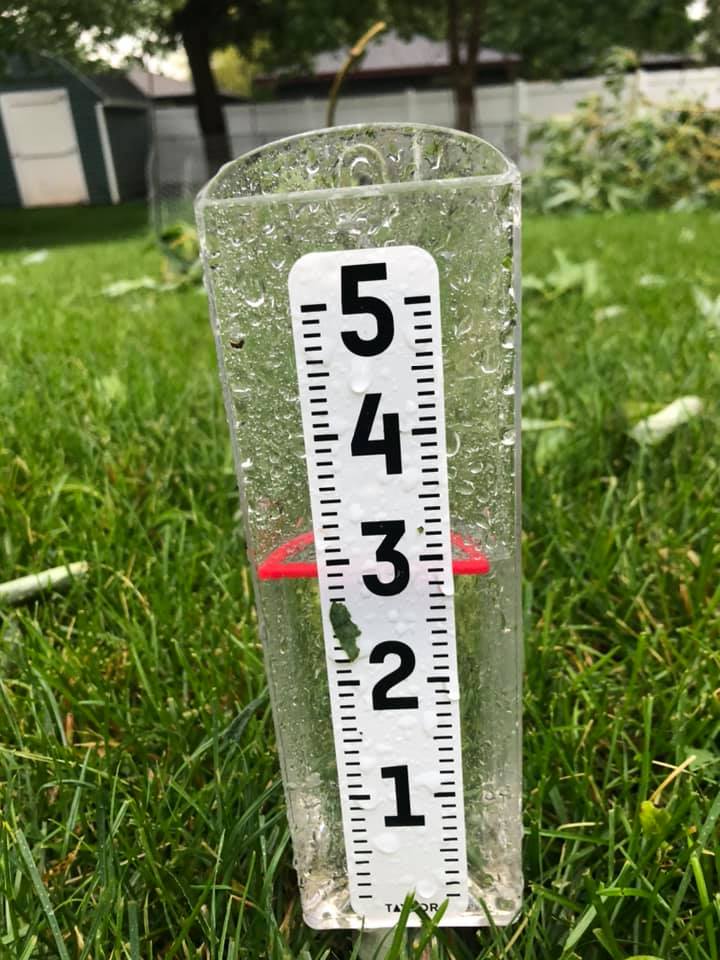
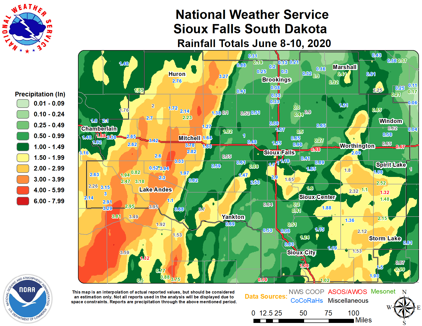
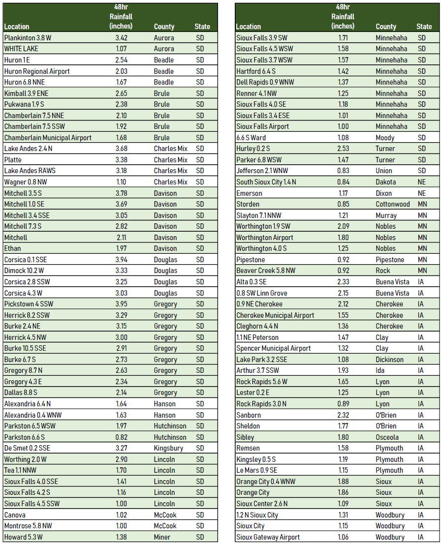
Rain Reports
 |
Media use of NWS Web News Stories is encouraged! Please acknowledge the NWS as the source of any news information accessed from this site. |
|


 Weather Story
 Weather Map
 Local Radar
 Follow us on YouTube