Strong winds moved along the Nebraska and South Dakota border into western Iowa last night. Winds gusted up to 57 mph which resulted in a few small branches coming off of trees. The strongest wind gust was near Concord, Nebraska which reached 57 mph. Other notable wind gusts were 53 mph near Fairfax, South Dakota and 45 mph at both Sioux City and Le Mars, Iowa. Additional wind gusts are shown on the map below.
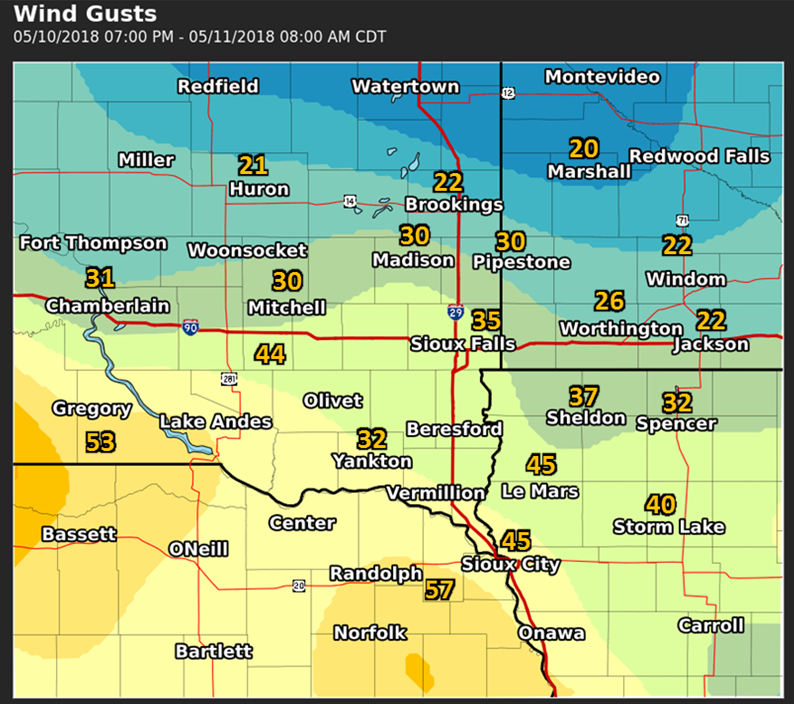
Map of peak wind gusts (mph) from the morning of May 11, 2018

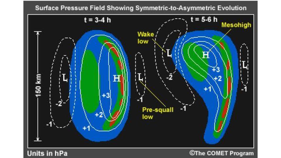
What caused the strong winds last night? The strong winds were associated with a wake low. What is a wake low? As you can see in the picture above, it is a small area of low pressure that forms 30 to 50 miles (50 to 100 km) behind a line of thunderstorms. The presence of the wake low results in a large pressure gradient between the line of thunderstorms and the wake low. As a result, air will accelerate toward the wake from the storm, producing strong easterly winds which reach their peak as the pressure reaches its lowest values. In some cases, wind gusts over 70 mph have been recorded with wake lows cause damage to trees and some buildings. One example is from June 22, 2015 which affect much of southeastern South Dakota and southwestern Minnesota. In addition, winds can gust over 40 mph for 30 to 60 minutes over even longer as a wake low moves through an area.
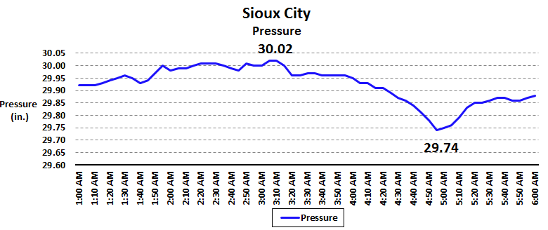
The data from Sioux City, Iowa (below) shows a great example of how winds and pressure change in the presence of a wake low. Above is a radar loop from 1 am to 7 am on May 11. Storms developed across western Nebraska and southwestern South Dakota in the evening and moved into the Sioux City area around 2 AM. Rain and thunder continued in Sioux City through 5 AM. Sioux City reached its maximum pressure around 3:15 AM shortly after the heaviest rain moved into the city. At that time winds gusted between 25 and 30 mph and the pressure reached 30.02 inches. After falling to 29.95 inches by 3:30 AM the pressure remain nearly steady through 4 AM and winds continued to gust between 20 and 30 mph. As the leading edge of the convection moved east of Sioux City at 4 AM, pressures began to fall rapidly over the next hour. Winds did not initially increase when the pressure began to fall. Around 430 AM winds began to increase above 30 mph. From 4:40 AM - 5:10 AM, winds gusted over 40 mph. The peak gust of 45 mph was observed near 5:00 AM at the same time the minimum pressure of 29.74 inches was seen. As pressures began to rise after 5 AM, the winds decreased and by 6 AM winds were back out of the east at 10 mph.

Here is how the radar looked at 5 AM when Sioux City had its maximum wind gust. Notice that the strongest winds and lowest pressure occurred at the back edge of the precipitation. This is the normal area where winds are strongest when associated with a wake low.


 Weather Story
 Weather Map
 Local Radar
 Follow us on YouTube