Go to our new page to check out all of the updates!

The National Weather Service Forecast Office at Indianapolis serves 39 counties of Central Indiana, carrying out the NWS mission of protecting life and property. To that end, our office issues weather and flood warnings, public forecasts, and advisories. The office is staffed 24 hours a day, 365 days per year to serve the citizens of Central Indiana. Learn more about our staff. Detailed information of our office's history can be found at this timeline, and detailed information about the city of Indianapolis can be found below.

Click image for larger version
The National Weather Service in Indianapolis consists of the following positions:
Here are the schools our staff attended to obtain their degrees:
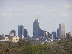
Known as the “Crossroads of America”, Indianapolis is located at the center of Indiana and is the state capital. As of the 2000 census, the city of Indianapolis had a population of over 882,000, which makes it the nations 15th largest city. The Indianapolis Metropolitan Area, consisting of Indianapolis and surrounding suburbs, has a population of over 2 million. The NWS office is located about 7 miles southwest of downtown, near the Indianapolis International Airport.
Climate of Indianapolis
Indianapolis experiences 4 distinct seasons during a year, from cold winters to warm and humid summers. During January the average high temperature is about 35 degrees with an average low of 19. During July the average high is 82 degrees with an average low of 65. The highest temperature ever recorded at Indianapolis is 107 degrees, and the coldest is -27 degrees. The city sees an average of 27 inches of snow per year and about 41 inches of precipitation per year.
Indianapolis Attractions
Commonly referred to as the "Racing Capital of the World," Indianapolis hosts the two largest single-day sporting events in the world: the Indianapolis 500 and the Allstate 400 at the Brickyard. Indianapolis is also home to several professional sports teams, including: the Indiana Pacers, Indiana Fever, Indianapolis Colts, Indianapolis Indians, and the Indianapolis Ice. The auto racing occurs at the Indianapolis Motor Speedway, while the most other teams listed all play in venues near downtown.
Downtown Indianapolis is home to the Indianapolis Zoo, White River Gardens, and the Indiana State Museum. Not far from downtown are the Indianapolis Museum of Art, one of the largest general art museums in the country, and the Children’s Museum, the world’s largest children’s museum with hands on exhibits.. Other attractions in the Indianapolis area include the Indianapolis Symphony Orchestra, and the Connor Prairie interactive history park.
For those who like to shop, destinations such as the downtown Circle Centre mall, the Fashion Mall, or the Broad Ripple area offer a variety of places to indulge.
Central Indiana is home to several state parks, most within a couple of hour drive of Indianapolis. These include Brown County State Park, Mounds State Park, and Turkey Run State Park.
Education
The Indianapolis Metro Area has several public school systems along with a variety of private schools. Higher education schools located in Indianapolis include but are not limited to: Butler University, Indiana University-Purdue University Indianapolis, Marian University, and the University of Indianapolis. Other universities located with Central Indiana include Ball State University in Muncie, Indiana University in Bloomington, and Purdue University in West Lafayette.

Transportation
The Indianapolis International Airport currently offers travel on 11 airlines to numerous destinations. Interstate highways 65, 69, 70, and 74 all serve the Indianapolis area. The IndyGo bus service provides public transportation around the city. Note that no public transportation is available to the NWS office location.
Housing
The median price of a new home in the Indianapolis area is approximately $125,000 (2003 data from US Census). The median rent for an apartment is approximately $650 (2003 data from US Census).
Taxes
Indiana has a 3.15% income tax, with counties taking out an additional income tax. Indiana sales taxes are 7%, with some counties adding additional sales taxes. More information on Indiana tax rates can be found at the Indiana Department of Revenue site.
Links to learn more about Indianapolis and Central Indiana:
Weather observations have consisted of daily readings of maximum and minimum temperatures, humidity, wind speed and direction, precipitation, atmospheric pressure and descriptions of weather conditions. Snowfall and snow depth readings began in March of 1884.
February 4, 1871 - U.S. Weather Bureau establishes an office in downtown Indianapolis in Blackford's Block on the southeast corner of Washington and Meridian streets (Latitude 39 deg 46 min N Longitude 86 deg 10 min W).
April 30, 1881 - The Weather Office was relocated to the Saks Building on the southeast corner of Washington and Pennsylvania streets (Latitude 39 deg 46 min N Longitude 86 deg 10 min W) .
September 1, 1896 - Another relocation occurred to the Majestic Building on the northeast corner of Maryland and Pennsylvania streets (Latitude 39 deg 46 min N Longitude 86 deg 10 min W).
July 1, 1915 - A move of the weather office placed it in the Consolidated Building at 115 N. Pennsylvania Street (Latitude 39 deg 46 min N Longitude 86 deg 10 min W) .
April 1, 1931 - A new Weather Office was opened in the administration building at Weir Cook Airport (Latitude 39 deg 44 min N Longitude 86 deg 16 min W) . The office downtown remained open and weather observations were taken at both locations but the official records were the readings from downtown.
October 28, 1938 - The final downtown move occurred when the weather office was moved to the Federal Building , bounded by New York , Pennsylvania , Ohio and Meridian streets (Latitude 39 deg 46 min N Longitude 86 deg 10 min W).
May 1, 1941 - A move of the airport office took place with the new location in the Roscoe Turner Aeronautical Building at the Weir Cook Airport (Latitude 39 deg 44 min N Longitude 86 deg 16 min W) . The hygrothermometer was installed and hourly temperature readings began.
January 1, 1943 - Observations continued to be taken at both the downtown and airport offices, but a switch was made making the Airport observations the Official Records from this point forward.
June 1954 - The weather office located in downtown Indianapolis was officially closed with all operations being consolidated with the Weir Cook Airport Office.
October 2, 1959 - Weather Service Radar (WSR-3) was installed at the airport office.
June 14, 1965 - The weather office was moved into Building #1 of the Weir Cook Airport (Latitude 39 deg 44 min N Longitude 86 deg 17 min W) .
June 19, 1970 - Internal restructuring within the National Weather Service changed the Indianapolis office to a Weather Service Forecast Office.
July 23, 1976 - The Weir Cook Airport name was changed to the Indianapolis International Airport .
September 28, 1977 - The National Weather Service office was relocated to the Administration Building at the Indianapolis International Airport (Latitude 39 deg 44 min N Longitude 86 deg 16 min W ).
September 28, 1977 - In conjunction with the move of the office to the Administration Building the WSR-3 radar was replaced with a WSR 74C radar.
May 1, 1992 - Construction began on the new National Weather Service building on West Hanna Avenue, south of the airport complex. Construction also began on the NEXRAD (Next Generation Radar) 88D.
August 24, 1993 - The National Weather Service office in Indianapolis moved in to its new office, where it currently resides. The NEXRAD 88D radar was made operational and ran in tandem with the WSR 74C radar until commissioning.
January 1, 1996 - Manual observations were replaced with an Automated Surface Observations Station (ASOS).
January 1, 1996 - The NEXRAD 88D radar was commissioned and the WSR 74C radar was officially decommissioned.
Present - The National Weather Service remains in its Hanna Avenue location to this date and continues to see internal advancements and updates in technology.


 Follow us on YouTube