
NWS Cheyenne Watches and Warnings

Wyoming Watches and Warnings


| Latest DSS Packet | Latest Graphical HWO |
 |
 |
| Latest Weather Story | |
|
Saturday Forecast
Weekend Forecast
Chillier Temps Next Week

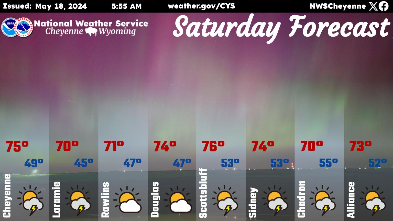
6AM, May 18th - Here’s your updated Saturday forecast! Expect highs in the low- to mid-70s across the region with clear skies turning partly cloudy. Could see a few pop up thunderstorms today for many locations.

6AM, May 17th - A warm weekend expected across the area, but daily afternoon shower and thunderstorm chances will persist. Partly cloudy skies Friday and Saturday before increasing cloud coverage returns for Sunday. Enjoy the weekend!

10AM 5/18 - While summer-like weather is dominating this weekend, multiple cold fronts next week will bring colder temperatures back to our area, especially Tuesday into Wednesday morning.
🌤️⚡ Expect warm weather to continue through the weekend, with a few showers this afternoon, and scattered thunderstorms on Sunday.
📉 Turning cooler and stormier on Monday. The best chance for rainfall and high elevation snowfall will be Monday through early Wednesday. Exact temperatures and how low snow levels will reach remains uncertain at this time.
🌦️ Additional storms systems will keep chances for showers and storms in the forecast through the end of next week, but the rainfall in this period is expected to be less widespread.
|
|
|
Saturday Forecast
Weekend Forecast
Chillier Temps Next Week
6AM, May 18th - Here’s your updated Saturday forecast! Expect highs in the low- to mid-70s across the region with clear skies turning partly cloudy. Could see a few pop up thunderstorms today for many locations.
6AM, May 17th - A warm weekend expected across the area, but daily afternoon shower and thunderstorm chances will persist. Partly cloudy skies Friday and Saturday before increasing cloud coverage returns for Sunday. Enjoy the weekend!
10AM 5/18 - While summer-like weather is dominating this weekend, multiple cold fronts next week will bring colder temperatures back to our area, especially Tuesday into Wednesday morning.
🌤️⚡ Expect warm weather to continue through the weekend, with a few showers this afternoon, and scattered thunderstorms on Sunday.
📉 Turning cooler and stormier on Monday. The best chance for rainfall and high elevation snowfall will be Monday through early Wednesday. Exact temperatures and how low snow levels will reach remains uncertain at this time.
🌦️ Additional storms systems will keep chances for showers and storms in the forecast through the end of next week, but the rainfall in this period is expected to be less widespread.
|


 Weather Story
 Weather Map
 Follow us on YouTube