 Open to the public, the Emergency Manager Briefing Page is a one stop shop for current and forecast events. The page is broken down into separate sections, including winter weather, severe weather, flooding, and heat. Local and national graphics include current watches and warnings, radar, outlooks, local storm reports, and forecast products. Open to the public, the Emergency Manager Briefing Page is a one stop shop for current and forecast events. The page is broken down into separate sections, including winter weather, severe weather, flooding, and heat. Local and national graphics include current watches and warnings, radar, outlooks, local storm reports, and forecast products.
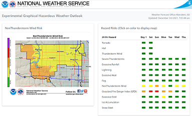 The Experimental Enhanced Hazardous Weather Outlook is a decision support service that supports preparedness and response efforts prior to and during hazardous weather. This service provides decision makers with convenient access to potential weather hazard information by graphically depicting the risk of weather hazards out through seven days across central and northeastern South Dakota and west-central Minnesota. The Experimental Enhanced Hazardous Weather Outlook is a decision support service that supports preparedness and response efforts prior to and during hazardous weather. This service provides decision makers with convenient access to potential weather hazard information by graphically depicting the risk of weather hazards out through seven days across central and northeastern South Dakota and west-central Minnesota.
 The ET forecasts provided on this page are the expected amount of daily reference evapotranspiration in hundredths of an inch for the next 7 days and a total reference of evapotranspiration for the 7 day period. The ET forecast is calculated by standardizing on the tall canopy vegetation (50 cm full cover alfalfa) algorithm. The ET forecasts are calculated using NWS forecasts of temperature, dewpoint, wind, and cloud cover. The ET forecasts provided on this page are the expected amount of daily reference evapotranspiration in hundredths of an inch for the next 7 days and a total reference of evapotranspiration for the 7 day period. The ET forecast is calculated by standardizing on the tall canopy vegetation (50 cm full cover alfalfa) algorithm. The ET forecasts are calculated using NWS forecasts of temperature, dewpoint, wind, and cloud cover.
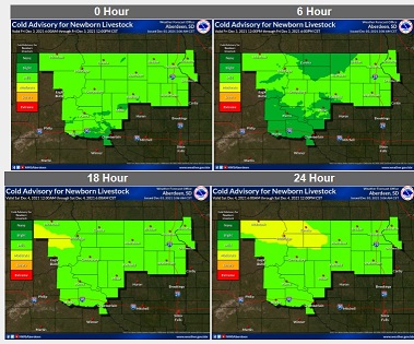 The Cold Advisory for Newborn Livestock (CANL) is based off of several currently available NDFD gridded forecast products, including temperature, wind, sky cover, and precipitation accumulations. Since winter conditions are most critical to livestock producers, the graphics will be run from mid-January through the end of May. A number of Weather Forecast Offices from Western and Central Region located in the upper Great Plains will be producing this advisory product. The Cold Advisory for Newborn Livestock (CANL) is based off of several currently available NDFD gridded forecast products, including temperature, wind, sky cover, and precipitation accumulations. Since winter conditions are most critical to livestock producers, the graphics will be run from mid-January through the end of May. A number of Weather Forecast Offices from Western and Central Region located in the upper Great Plains will be producing this advisory product.
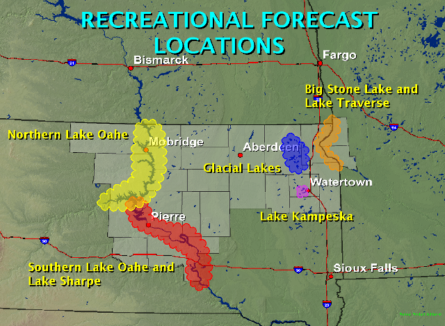 The Recreational Forecast contains forecasts and reports on conditions for resort and recreational areas. The forecast will be issued one per day between 4am LST and 6am LST and will include a site specific forecast for the following weather elements: max/min temperatures, sky/weather, wind speed and direction, lightning, and even a 2-Day extended forecast. The Recreational Forecast contains forecasts and reports on conditions for resort and recreational areas. The forecast will be issued one per day between 4am LST and 6am LST and will include a site specific forecast for the following weather elements: max/min temperatures, sky/weather, wind speed and direction, lightning, and even a 2-Day extended forecast.
 The UV-Index Forecast page contains links to NWS/EPA UV-Index forecasts. The UV index is a measure to help you determine the effects of the sun on outdoor activities. The UV-Index Forecast page contains links to NWS/EPA UV-Index forecasts. The UV index is a measure to help you determine the effects of the sun on outdoor activities.
|


 Follow us on YouTube