
Isolated to scattered severe thunderstorms appear possible across portions of the Southeast and Carolinas on Saturday where a Slight Risk (Level 2 of 5) has been issued. A Slight Risk Excessive Rainfall Outlook (Level 2 of 4) has been issued for part of the northern Gulf Coast Saturday due to the threat of flash, urban, and riverine flooding. Read More >
| NWR Transmitters | Transmitter Quick Reference | SAME & ZONE Codes | Other Information | Questions & Comments? |
|---|
NOAA Weather Radio (NWR) is the official voice of the National Weather Service. As such, it is important that the NWR broadcasts adhere to the highest standards of timeliness, completeness and accuracy. The objective of NWR is to provide a continuous flow of timely and accurate weather and hydrologic information directly to listeners in the service area of the NWR transmitters.
Each transmitter has a normal range of 35 to 40 miles, but with a high quality receiver and antenna, the signal can be picked up at greater distances. The broadcasts can be heard on special weather radio receivers programmed to pick up frequencies between 162.400 and 162.550 MHz, and on scanners with a special weather band. Weather radios can be purchased at most electronic stores and average between $20 and $70.
One of the most beneficial features of NWR is that when a severe weather warning is issued by the National Weather Service in your area, a tone alarm is also transmitted so that your weather radio will play an audible alert to notify you that a severe weather warning will follow. In addition, NOAA Weather Radios are equipped with a new technology called SAME, which stands for Specific Area Message Encoder. This will allow you to program your weather radio to alarm only for the counties that you select. (Look below for SAME codes for your county and others.)
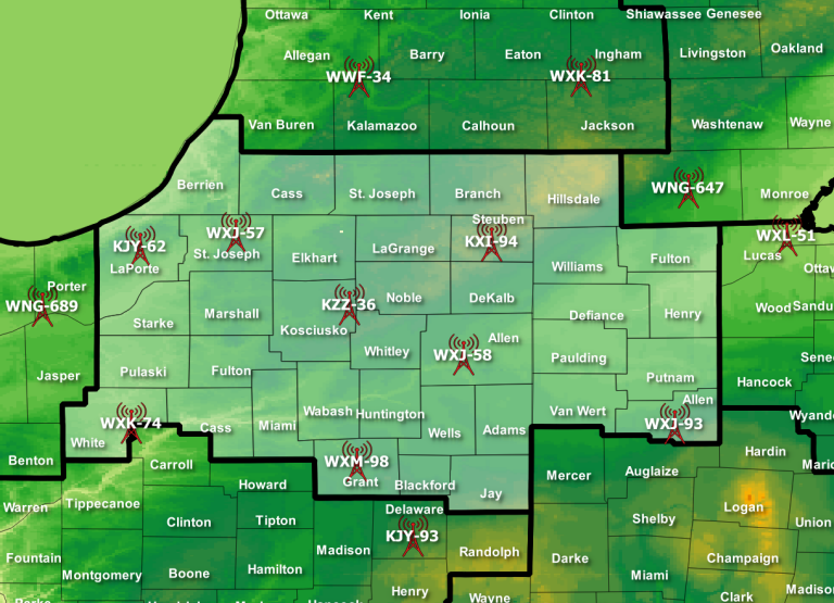
The map below shows the location of each transmitter in our area as well as the surrounding transmitters that cover certain counties in our forecast area.
Scroll over any transmitter to see which counties are covered by that transmitter and
click on any transmitter to access the transmitter coverage maps from the National Weather Radio website.
| Name | Abbreviation | Call Letters | Frequency |
|---|---|---|---|
| South Bend | SBN | WXJ-57 | 162.400 |
| North Webster | IWX | KZZ-36 | 162.500 |
| Fort Wayne | FWA | WXJ-58 | 162.550 |
| Angola | ANQ | KXI-94 | 162.425 |
| La Porte | LAP | KJY-62 | 162.500 |
| Name | Abbreviation | Responsible Forecast Office | Call Letters | Frequency |
|---|---|---|---|---|
| Marion | MAR | Northern Indiana Grant County |
WXM-98 | 162.450 |
| Muncie | MUN | Indianapolis | KJY-93 | 162.425 |
| Plainwell | PLN | Grand Rapids | WWF-34 | 162.475 |
| Onondoga | ONO | Grand Rapids | WXK-81 | 162.400 |
| Toledo | TOL | Cleveland | WXL-51 | 162.500 |
| Yeoman (Monticello) | LAF | Indianapolis | WXK-74 | 162.475 |
| Cridersville (Lima) | LIM | Wilmington | WXJ-93 | 162.400 |
| Adrian | ADR | Detroit | WNG-647 | 162.450 |
| Hebron | HEB | Chicago | WNG-689 | 162.450 |
| Local SAME and ZONE county codes | National SAME and ZONE county codes | Marine SAME and ZONE codes |
|---|---|---|
| Click for Northern Indiana counties | Click to find any counties in any state | Click to find any marine areas |
 |
 |
 |
| Click for a text listing of local SAME Codes |
If you are experiencing problems with your weather radio whether it be not receiving the Wednesday tone alert test, have noticed the station you were listening to has gone off the air, or you just have a question...contact your local NOAA Weather Radio program at nws.northernindiana@noaa.gov, call 1-888-886-1227, or go to the NWR Transmitter Problem Homepage.


 Follow us on YouTube