|
|
Introduction
Increased scientific understanding of tornadoes and technological advances have allowed the National Weather Service to dramatically improve tornado warning capabilities over the last 50 years. Arguably, no technological advance has had a more dramatic effect on issuing tornado warnings, than has radar. Here we explore the evolution of weather radar in Southeast Michigan from the earliest WSR-3 to today's WSR-88D Doppler radar.
WSR-3 Radar
At the time of the Flint-Beecher tornado, there was no weather radar network in existence. The first weather radar in Southeast Michigan was a Weather Surveillance Radar (WSR)-3 radar, a surplus Navy 3 cm radar. This radar, installed at Metro Airport, was commissioned on May 15, 1957. An example of the resolution of the WSR-3 radar is shown in this picture.
WSR-57 Radar

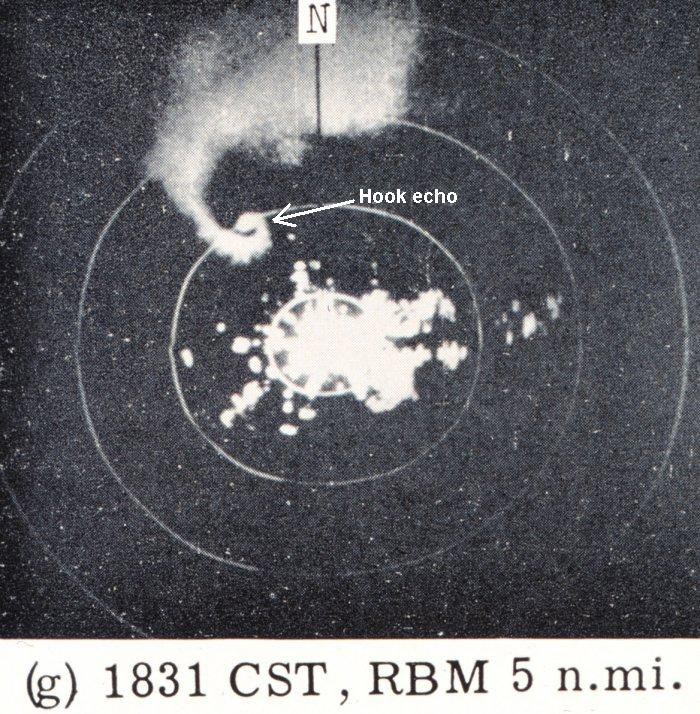
In 1959 the first "modern" radar, the WSR-57, was commissioned at the Miami hurricane forecast center. Over the next few years, this technology was installed across the country. Detroit received its WSR-57 on September 12, 1961. The WSR-57 offered some improvement over the WSR-3, but with coarse reflectivity and no velocity data available, the ability to forecast tornadoes was limited. The picture below shows the WSR-57 image of the tornado that struck West Bloomfield in Oakland County on March 20, 1976.
WSR-88D

The truly modern era in weather radar surveillance began in Detroit on June 19, 1993 when the WSR-88D began operations at the new NWS office serving Southeast Michigan from White Lake, Oakland County. The "D" in WSR-88D stands for Doppler. And it is the Doppler technology that has revolutionized weather forecasting over the last decade by allowing meteorologists to observe storm motion. As Dick Wagenmaker, Meteorologist-in-Charge at the White Lake NWS office observes, "The advent of Doppler radar allows meteorologists the ability to better detect tornadoes, especially the F4s and F5s like the West Bloomfield and Flint-Beecher tornadoes, than we could with earlier technology." The significant improvement in the WSR-88D's ability to isolate tornadic features in radar data from earlier radars is easily apparent in the image below. Here a Doppler velocity product from the NWS Northern Indiana WSR-88D captures the dramatic signature of a tornado over Van Wert County, Ohio.
|
||
How Does Doppler Radar Work?
Doppler Radar detects the presence and location of an object by bouncing an electromagnetic signal off of it and measuring the time it takes for the signal to return. This measurement is used to determine the distance and direction of the object from the radar. In the case of radar meteorology, the "objects" being measured are the particles of water, ice or dust in the atmosphere. Doppler radars take additional advantage of the fact that radar signals reflected from a moving object undergo a change in frequency related to the speed of the object traveling to or away from the radar antenna. Therefore, using Doppler technology, the WSR-88D calculates both the speed and direction of motion of severe storms. By providing data on the wind patterns within developing storms, the WSR-88D identifies the conditions leading to severe weather. A developing tornado, for example, can be detected forming miles above the earth before it reaches the ground. This means earlier detection of the precursors to tornadoes, as well as data on the direction and speed of tornadoes once they form. Accessing Radar Data

The White Lake Doppler radar is one of 120 NWS Doppler radar sites across the Nation. Access to the White Lake radar data is available on the internet here. This site also offers access to all other NWS radar data.
Acknowledgements | Site Map | Other Resources
Legal Notice | Disclaimer | Privacy Notice | Contact Us National Weather Service |
|||
|
|||


 Follow us on YouTube