National Weather Service United States Department of Commerce

NWS Springfield, Missouri Fire Weather


Fire Weather Spot Forecast Requests Via the Internet:

Spot Forecasts are issued for prescribed burns, wildfires, spray projects, or any number of land management activities within our forecast area. Government agencies anywhere within our fire weather forecast area can request a spot forecast.

Click Here For A Spot Forecast For Prescribed Fire or Wildland Fire Incidents

To public safety or government emergency management agencies:  For weather support information for non-wildland fire related incidents or weather sensitive events please contact the National Weather Service directly to arrange support.

YouTube Video Tutorial 


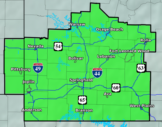
                         Fire Weather Forecast by County (clickable map)


National Weather Service (NWS) Links
NWS National Fire Weather Web Page    National GIS Viewer - Fire Page  (experimental)
Fire Weather Forecast (Text)
Fire Wx Watch/Red Flag Warning (Text)
NWS Fire Weather Dashboard Point Forecast (experimental not supported 24/7)  
NWS Decision Support Point Forecasts (experimental)
SAFER (experimental)
NWS Graphical Forecasts
NWS Weather Activity Planner     NWS User Defined Area Forecast
NWS Springfield Hazardous Weather Outlook

NWS Springfield County Based Grassland Fire Danger Index (GFDI)

NWS Storm Prediction Center Fire Weather Page

NWS Weather Prediction Center

Climate Prediction Center (6-10 and 8-14 Day Outlooks, Monthly and Seasonal Outlooks)

NWS Advanced Hydrologic Prediction Service Precipitation Analysis

Smoke Dispersal(Ventilation Rate)

Weather Alert Tool Information
Wireless Emergency Alerts (WEA)
InteractiveNWS (iNWS) is the home of mobile and desktop innovations of the National Weather Service.
Weather APPS - Weather Enterprise applications including links to commercial, academic, and governmental products and services
Land Management Partners Federal

National Interagency Coordination Center (NICC)

InciWeb Incident Information System
Public Fire Information Websites  
National Wildland Significant Fire Potential Outlook
Eastern Area Coordination Center (EACC) Predictive Services Weather Briefing
U.S. Forest Service Wildland Fire Assessment System (WFAS)

Missouri Iowa Interagency Coordination Center (MOCC)            Mark Twain National Forest

WildCAD - Mark Twain/Missouri Iowa Coordination Center Incidents Dashboard
Mark Twain National Forest Situation Report
U.S Fish and Wildlife Service - Fire Management Program
Land Management Partners Missouri

Missouri Department of Conservation (MDC)

MDC Wildfire Prevention
MDC Fire Management
MDC Database Missouri Wildfire Statistics
Missouri State Parks
Land Management Partners Kansas
Kansas Forest Service Fire Management Program
Kansas Department of Wildlife, Parks and Tourism
Fire Science and Education 
Specialized information for Wildfires in the Midwestern U.S.  (Midwest Climate Center)
Fire Climatology 1992-2015 (Storm Prediction Center)

Great Plains Fire Science / Oak Woodlands & Forests Fire Consortium / Joint Fire Science Program

Eastern Area Modeling Consortium / Rocky Mountain Center Research Center

Firewise Communities

National Weather Service (NWS) Wildfire Safety

NWS Seasonal Safety Campaign
Ready.gov Web Resource
Smokey Bear for Kids
Smokey Bear for Educators
Missouri Prescribed Fire Council
Drought Information
U.S. Drought Portal 

U.S. Drought Portal: Data and Maps - Outlooks and Forecasts

Drought Missouri       Drought Kansas

U.S Drought Monitor
Midwest Climate Center Vegetation Impact Program (VIP)     Keetch-Bryam Drought Index (KBDI)   
Missouri Burn Ban Information
Smoke Management

AIRNow.gov (Air Quality Monitoring Page)

Southern High Resolution Modeling Consortium (SHRMC) Smoke Management Tools
 
HRRR Smoke Model/Simulation      HRRR Smoke Map
NOAA Hazard Mapping System Fire and Smoke Product
HYSPLIT Air Resources Laboratory (ARL)
Satellite Imagery
GOES East    GOES-East - Regional sector view: Upper Mississippi Valley
Mesoscale Imagery (higher frequency, small area, varies based on operational needs)
RealEarth Viewer (University Of Wisconsin) 
Other GOES Resources
College of DuPage Satellite Imagery Page
Satellite Imagery Web Based (Colorado State Univ)

Area Observations (note observation platforms are not operated by the NWS)

NWS Regional Observations Map

MesoWest (Univ. of Utah) 
National Weather Service Enhanced Data Display
Community Collaborative Rain, Hail and Snow  Network (CoCoRaHS) 
Ava/Tidwell Site (NFDRS-SGF) Camdenton  (NFDRS-SGF) Cassville (NFDRS-SGF) Mt. Vernon  (NFDRS-SGF)
Mountain Grove (NFDRS-SGF) Mountain View (NFDRS-SGF) Roby  (NFDRS-SGF) Wah Kon Tah (NFDRS-SGF)
Ashland Big Spring Carr Creek Clinton
Council Bluff Doniphan Farmington Piedmont
Sinkin State Line, KS Sullivan  
Area Airport Observations (ASOS/AWOS 10m Wind Towers)
Missouri
Bolivar AWOS Branson AWOS Branson West AWOS Camdenton AWOS
Clinton AWOS Farmington AWOS Ft. Leonard Wood  ASOS Joplin ASOS
Lebanon AWOS Monett AWOS Neosho AWOS  
Osage Beach AWOS Piedmont AWOS Rolla/Vichy ASOS Sedalia ASOS
Springfield ASOS Sullivan AWOS Warrensburg AWOS Warsaw AWOS MODOT Link
West Plains ASOS Whiteman AFB ASOS    
Kansas and Oklahoma
Chanute KS ASOS Fort Scott KS AWOS Grove, OK AWOS Parsons, KS  ASOS
Pittsburg, KS AWOS      
Arkansas
Bentonville, AR AWOS Flippin, AR AWOS Harrison, AR ASOS Mountain Home, AR ASOS
Rogers, AR AWOS      

Cook Station Crawford Co. x

Green Ridge  x

Lamar   x Mountain Grove   X

Mount Vernon    x

Versailles   x

   
Near Arma, KS 10 WSW Salem, MO    
Nearby Oklahoma Mesonet Stations (far northeast Oklahoma)
Miami Jay Westville OK-FIRE
National Fire Danger Rating System (NFDRS) and RAWS Information
Tabular NFDRS Observations and Forecast From WIMS (U.S. Forest Service)
Observed and Forecast Fire Danger Rating Maps (Wildland Fire Assessment System)
Mark Twain National Forest Fire Danger Rating Matrix Chart
Fire Weather Operating Plan

Fire Weather Operating Plan (.pdf)