

Precipitation

In order for precipitation to form, particularly over a large area, several ingredients are necessary. First there must be a source of moisture. The primary moisture sources in the U.S. are the Atlantic and Pacific Oceans as well as the Gulf of Mexico. Winds around high- and low-pressure systems (a subject of another lesson) transport this moisture inland.
Once the moisture is in place, clouds still need to form. The most effective way to do this is by lifting the air. This can be accomplished by forcing the air up and over mountains or, more commonly, by forcing air to rise near fronts and low-pressure areas.
Cloud droplets and/or ice crystals are too small and too light to fall to the ground as precipitation. So, there must be a process(es) for the cloud water, or ice, to grow large enough to fall as precipitation. One process is called the collision and coalescence or warm rain process. In this process, collisions occur between cloud droplets of varying size, with their different fall speeds, sticking together or coalescing, forming larger drops.
Learning Lesson: Atmospheric collisions
Finally, the drops become too large to be suspended in the air and they fall to the ground as rain. The other process is the ice crystal process. This occurs in colder clouds when both ice crystals and water droplets are present.
In this situation it is "easier" for water vapor to deposit directly onto the ice crystals so the ice crystals grow at the expense of the water droplets. The crystals eventually become heavy enough to fall. If it is cold near the surface it may snow, otherwise the snowflakes may melt to rain.
Learning Lesson: It's the "Rain", Man
The Community Collaborative Rain, Hail, and Snow Network
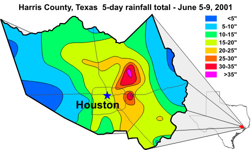
In June 2001, Tropical Storm Allison deposited a tremendous amount of rain in southeast Texas. In Harris County alone, up to three feet of rain fell near Houston, Texas during a 5-day period. This map (right) of Harris County shows the rainfall distribution. The difference in rain across the county ranged from less than 5 inches (127 mm) to nearly 37 inches (940 mm).
Large differences in rainfall amounts are more common than one would normally expect. But often these large differences are not seen in the rainfall data due to the distances between "official" rain gauges.
What IS CoCoRaHS?
CoCoRaHS is a unique, non-profit, community-based network of volunteers of all ages and backgrounds working together to measure and map precipitation (rain, hail and snow). You can help fill gaps in the rainfall data by becoming a volunteer and taking measurements of precipitation from your location.
Everyone can help, young, old, and the in-between. For educators, your school and students (both at school and at home) are encouraged to participate; the more the better. The only requirements are an enthusiasm for watching and reporting weather conditions and a desire to learn more about how weather can affect and impact our lives.

The program helps meteorologists, hydrologists, and researchers study the variability of precipitation and the accumulated data will be available to anyone with a use or interest in precipitation data. The data collected by CoCoRaHS also supports the weather forecasting and warning responsibilities of the NWS.
How did CoCoRaHS get started?
CoCoRaHS started because of a devastating flood that struck Fort Collins, Colorado in 1997. When researchers went back to examine the precipitation data, they discovered that the heaviest rainfall leading to the flood missed all of the official gages. Colorado State Climatologist Nolan Doeskin developed a new volunteer observing network to fill in the gaps between official gages called CoCoRaHS. In the years since, CoCoRaHS has expanded rapidly with over 6,500+ observers in twenty-six states.
What is involved to be a CoCoRaHS?
As the case with all types of data collection, accuracy and consistency are the keys to ensure the observations are meaningful. With that, there are certain types of rain gauges that should be used. The most common, called a 4" rain gauge (left), makes reading accurate rainfall amounts easy. The funnel collects up to one inch in the rain in the measuring tube with amounts greater than one inch spilling into the overflow tube. Visit CoCoRaHS for more info on this gauge.
Why not use automatic rain gauges that come with many electronic home weather stations?
It goes back to the consistency aspect of collecting data. Not all rain gauges are created equal nor do they all report the same. The majority of automated rain gauges, when summed over several months or years, report less precipitation than actually fell, and sometimes by a significant amount -- sometimes 25% or more. Also, most automatic gauges cannot collect snow.

Because of these test results, CoCoRaHS asks the observers to set up a CoCoRaHS 4" gauge along with their automated gauge and see for themselves. Many observers have converted to using the 4" gauge as their daily measurement when they see the results, and then use their automated gauge as a backup when they are gone.
CoCoRaHS provides instruction on how and where to set up your equipment as well as how to read and report your observations. You will also be able to see a map of CoCoRaHS observations for your region in "real time." Become a part of CoCoraHS!