
Event Summary
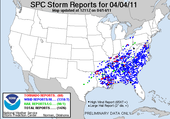
A powerful storm system took shape across the central United States and clashed with a warm and unstable airmass. An extensive and intense squall line resulted which quickly pushed eastward across the eastern half of the country. Overall, this system produced a large severe weather outbreak and brought widespread wind damage to multiple states across the south, mid south, and southeast United States. Nearly 1450 reports of severe weather have been reported so far, across 15 states, with the vast majority being damaging winds. Wind damage was not the only severe weather event type, large hail and tornadoes were also part of the mix, with roughly 60 tornadoes reported up to this point. In terms of total events (storm reports), this outbreak is approaching record breaking status and will make a run at the #1 ranking after further verification is done and storm surveys are completed.
Across the National Weather Service Jackson forecast area, numerous reports of down trees and power lines have been reported along with multiple reports of damaged structures. These structures were damaged by either fallen trees or intense winds. At this time, survey teams have found 5 tornadoes across the area, two of these were rated EF2. The first strong tornado moved into northwest Catahoula Parish from LaSalle Parish. The other strong tornado occurred across Tensas Parish and tracked to the MS River, crossed the river and dissipated in far northwest Claiborne County. The other three tornadoes were rated EF1. One of these occurred just north of Utica, in Hinds County, another tracked across northern Simpson County near Braxton, and the other across southeast Lincoln and southern Lawrence Counties. Specific information on each event can be found in the local storm report map and storm survey table below.

Survey Information - Click on the location in the table for additional maps and details
| Location | Start/ End Time |
Event Type | Fatalities/ Injuries |
Path Length | Path Width |
| Catahoula Parish 8 miles SW Enterprise to 3 SW Enterprise |
Mon 4/4 3:04 pm- 3:09 pm |
EF-2 Tornado 115 mph |
0 | 5 miles (13 total) |
0.25 mile |
| Tensas Parish 1.5 miles SSE Cooter Point LA to 1.5 miles N Grand Gulf MS |
Mon 4/4 3:43 pm- 4:14 pm |
EF-2 Tornado 125 mph |
1 | 27 miles | 0.5 mile |
| Simpson County 5 miles WSW Braxton to 3 miles ENE Braxton |
Mon 4/4 5:36 pm - 5:42 pm |
EF1 Tornado 100 mph |
0 | 8 miles | 0.75 mile |
| Hinds County 1.5 miles NNW of Utica to 4 miles NE Utica |
Mon 4/4 4:42 pm - 4:45 pm |
EF-1 95 mph |
0 | 3.5 miles | 0.25 mile |
| Lincoln and Lawrence Counties 1 1.5 miles W of Ruth to 7.5 miles ESE Topeka |
Mon 4/4 5:48 pm - 6:07 pm |
EF-1 100 mph |
0 | 16.5 miles | 600 yds |
| Jefferson Davis County Society Hill |
Mon 4/4 6:20 pm |
Straight Line Winds | 0 | N/A | N/A |
Rainfall Information
Over three inches of rain fell over a corridor from the Golden Triangle southwest through Kosciusko. Significant flash flooding was reported in the Columbus area, with water entering businesses. Several roads were closed across Lowndes County.


 Follow us on YouTube