Between 1:30 pm cst and 430 pm cst on Sunday, November 27th, 2005, a total of 7 tornadoes touched down in the NWS Wichita CWA in east central and southeastern Kansas. This was only the 3rd time since 1985 that tornadoes had occurred in the month of November in Kansas, and therefore as Jon Davies put it, this was a "rare event". Four of the tornadoes in Marion County were believed to be directly associated with the Cold Core 500 mb low climatological/synoptic pattern identified by Davies and Guyer 2004. The other 3 tornadoes across Montgomery, Neosho, and Allen Counties appeared to be within the traditional warm sector, occurring just east of the dryline surge.
Figure 1 shows a four panel of the ETA at 18z, which depicts the closed 500 mb low center in extreme southwestern Kansas, a 985 mb surface low in central Kansas with lower to middle 50s surface dewpoints from east central through southeastern Kansas. Also, one can see hints of the dry slot at 700 mb nosing into south central kansas from Oklahoma.
 Figure 2a |
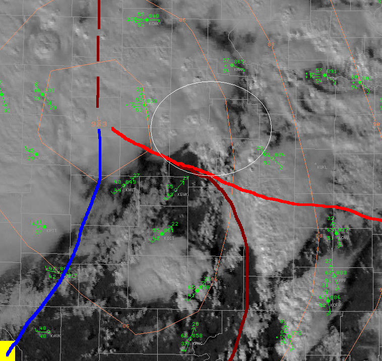 Figure 2b |
Figure 2a (above left) is a surface composite pattern identified by Davies and Guyer 2004 that illustrates the most likely or favorable area for tornadoes directly in association with the closed core 500 mb low. Figure 2b (above right) shows a surface map analysis at 20 UTC 27 November 2005. Strong surface low pressure (985 mb) was over central Kansas with a pseudo-warm front extending from the low across east central Kansas. Dewpoints in the lower 50s can be seen along and north of the warm front. A dryline (brown) had surged into east central Oklahoma and extended northward up through the Flint Hills into the warm front. The white oval area represents the most favorable zone for tornadoes associated with the closed core 500 mb low. This area is just north of the boundary intersection focus point. A mid level dry air intrusion surged northward into south central Kansas behind the dryline allowing for partial sunshine and diabatic heating. This was crucial as the diabatic heating allowed low-level lapse rates to steepen dramatically in only a 1 to 2 hour period underneath strong mid level cold air advection in association with the approaching upper low.
 Figure 3a Figure 3a |
Figure 3a (left) shows the 19z LAPS 0-3 km CAPE as image color. The purple color represents 0-3 km CAPE in excess of 100 J/KG across east-central Kansas including Marion County. Note how the low-level CAPE was pooling along and north of the warm front in east-central Kansas. The green contours are LAPS surface-based CAPE values of 700 to 962 J/KG across the same area of concern. METAR plots are overlaid and showed southeasterly surface winds of 20 to 25 kt sustained which yielded 0-1 km SRH (figure 4) of 200-300 m2/s2. Deep layer shear was approximately 40 to 45 kt. |
 Figure 3b |
Figure 3b (left) shows the 19z RUC for the same parameters as in Figure 3a above. With regard to the low-level (0-3 km) CAPE, note how the 19z RUC did not show near the resolution or detail when compared to the 19z LAPS. In addition, the surface-based CAPE was not as high as with the LAPS data. |
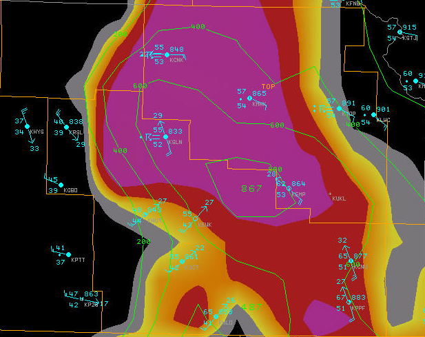 Figure 3c |
By 20z however (Figure 3c), it appeared that the RUC had caught up to LAPS and was showing better resolution and detail on the 0-3 km CAPE in addition to more representative surface based CAPE values over east central Kansas. |
A cluster of "mini" (or low-topped) supercells developed over east central through south central Kansas between 18 UTC and 19 UTC, likely resulting from diabatic heating and strong theta-e convergence in the vicinity of the dryline and warm front intersection zone. Four tornadoes (all rated F0) occurred in Marion County between 1948 and 2004 UTC. The freezing level was about 9,000 ft AGL with the minus 20 celsius height at only 19,000 ft AGL, which contributed to the low-topped nature of the convection. Echo top heights were averaging only 30,000 to 35,000 ft AGL during the afternoon hours. The strongly-sheared environment with high SRH values in conjunction with strongly positive values of 0-3 km CAPE and negligible CIN contributed to a primed environment for mini-supercell tornadoes. The high values of low-level CAPE also likely contributed to rapid vertical stretching of updrafts in the vicinity of and north of the warm front in east-central Kansas. LCL heights (not shown) were around 400 to 500 m AGL throughout the afternoon in central and southeastern Kansas which is favorable for tornado formation.
 Figure 5a |
In Figure 5a (left top) is a KICT 4 panel of 8 bit reflectivity at 1920 UTC 27 November 2005, showing the 0.5, 0.8, 1.3, and 1.5 degree slices. Within the white oval circle, a mini-supercell can be seen over southern Marion County with a low-level inflow notch and a V-Notch signature. Figure 5b (left bottom) shows the corresponding KICT 4 panel of 8 bit SRM data for the same elevations and time as in Figure 5a. A rotational velocity couplet can be easily identified for this storm. This particular storm produced two of the tornadoes in Marion county between 1948 and 2002 UTC, with one of the tornadoes having a path length of 13 miles. The radar operator noted weak-moderate mesocyclone strength throughout most of this storms life in Marion County. This was a similar characteristic to most or all of the low-topped supercells on this Sunday afternoon. Figure 6 is a photo of one of the tornadoes in Marion County captured by Dick McGowan and Darin Brunin. |
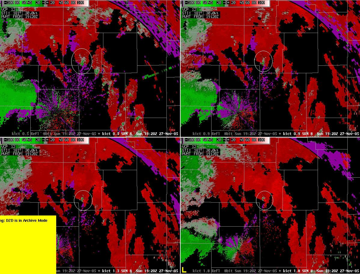 Figure 5b |
From a warning operator perspective on this event, the mini-supercells in east central Kansas were moving fairly quickly at 40 to 45 mph to the northeast. With most of the rotation signatures confined to the lower portions of the storms, as the storms moved further away from the radar, they would appear to weaken and lose their rotation, when in fact this was not true! This made for a difficult warning environment. In these kind of circumstances, warning operators would need to heavily lean toward the environment when deciding on warnings. If a warning operator is on the fence on whether or not to issue a tornado warning versus a severe thunderstorm warning in an environment that is very conducive to tornadoes, prudence may dictate to issue the tornado warning.
The tornadic storms that affected Montgomery, Neosho, and Allen Counties occurred between 2048 UTC and 2222 UTC Sunday afternoon and occurred just east of the advancing dryline in southeastern Kansas. These storms occurred in the warm sector, however they also displayed mini-supercell characteristics very similar to the ones in east central Kansas. The following parameters (not shown) suggested a favorable environment for tornadoes: low LCL heights of 400 to 600 m AGL, 0-3 km CAPE in excess of 100 J/kg, 0-1 km SRH of up to 300 m2/s2, 0-6 km shear of 60 to 80 kt. In addition, the dryline provided the focusing mechanism for convergence and lift. These tornadic supercells moved consistently to the northeast at 60 mph! Again, given the low-topped storm nature and location of these storms being relatively far away from the KICT, KTWX, KSGF, and KINX radar sites, it made for a very difficult warning environment. In particular, as one of the tornadic storms moved northeastward from Neosho County into Allen County, the storm appeared to weaken and lose it's rotational velocity signature off the KINX radar. When in fact, the 0.5 degree elevation slice was at least 10,000 ft AGL. No matter which radar one uses in this part of our CWA, the 0.5 degree beam height is upwards of 10,000 ft AGL. With most of the rotation being confined to the lowest 10,000 ft of these storms, it was rather deceptive when the storms appeared to be weakening per radar. Again, in these low-topped, but primed environments for tornadoes, if a warning operator is on the fence on whether or not to issue or continue a tornado warning versus a severe thunderstorm warning, prudence may dictate to issue the tornado warning.


 Follow us on YouTube