Severe Thunderstorms roll across Kauai and Oahu January 8-9, 2005
Summary:
During the evening and overnight hours of January 8 and 9, a line of powerful thunderstorms moved across Kauai and Oahu producing strong wind gusts, wind damage and a small tornado. In fact, this line was identical to systems that usually affect the Central Plains and eastern parts of the mainland during spring and summer. Although relatively rare for Hawaii, such strong to severe thunderstorms do occur, mainly during the winter, when strong cold fronts and jet stream dynamics are most likely to reach as far south as Hawaii.
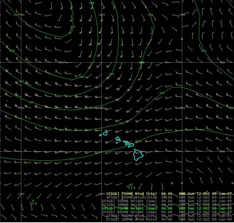
In this particular case, we had a combination of strong low level winds (40-50 mph) ahead of an approaching cold front providing convergence and strong jet stream winds high aloft (100 mph), providing upper level divergence, in the area. These ingredients, combined with moisture and instability, resulted in the development of the thunderstorms. This is a classical setup for the development of strong to severe thunderstorms.
300 mb ( 30,000 ft) weather pattern
700 mb (10,000 ft) weather pattern
850 mb (5,000 ft) weathern pattern
surface weather pattern
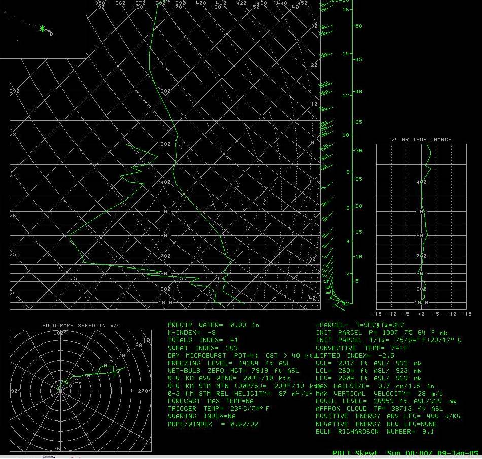
The upper air sounding taken at 2pm January 8 from Lihue indicated a somewhat unstable atmosphere with strengthening winds, however moisture was lacking. Otherwise it would have matched the classic severe thunderstorm sounding. Although no sounding was taken before the storms, a model derived sounding valid for 8pm January 8 over Lihue indicates a rapid increase in moisture and a more unstable environment.
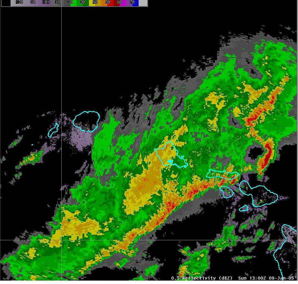
The thunderstorms quickly developed west of Kauai and formed into a solid line. As the line approached Kauai, several "bow echoes" formed along the line. These bow echoes, which take on a bow or comma shaped appearance, are a signal of very strong and damaging winds occuring. At the top of these bows, tornadoes are also possible.
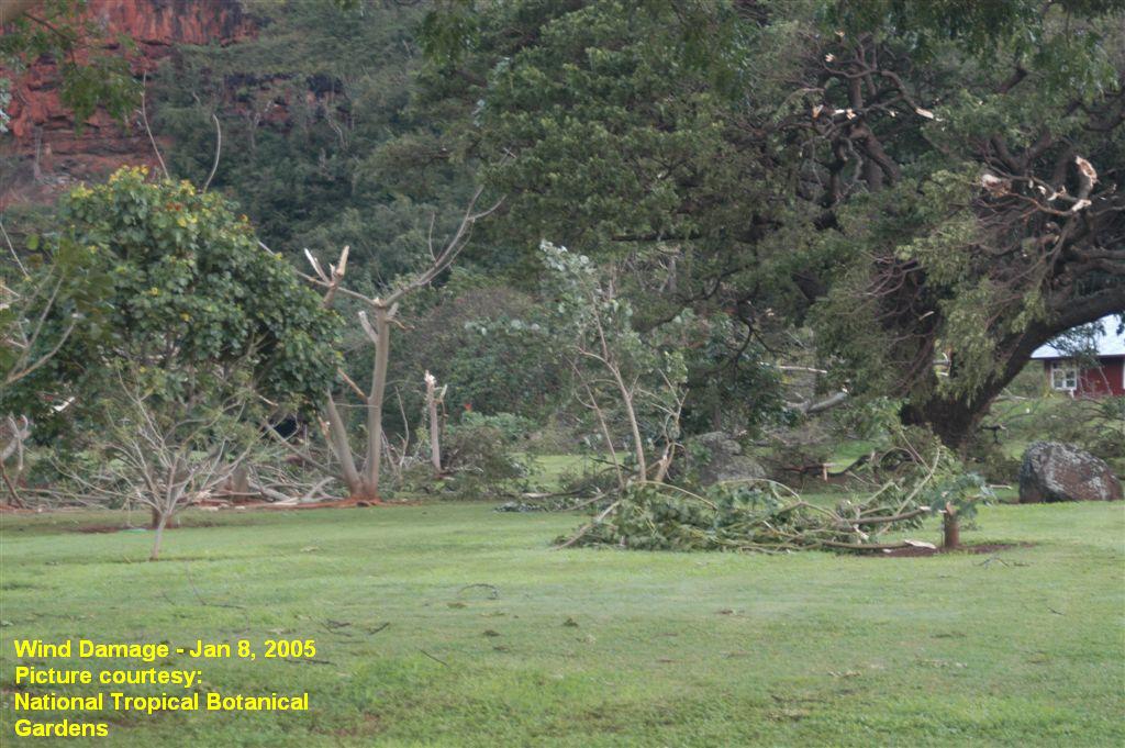
One particular bow echo formed just southwest of Kauai. The top part of the bow moved across extreme southern Kauai, and produced a tornado in Waimea and significant wind damage at the Botanical Gardens in Kalaheo. That bow continued across the Kauai Channel and strengthened and likely produced a large tornadic waterspout and winds in excess of 60 knots (70 mph) over the water. In fact, the tornado detection algorithm from the Kauai radar signalled the presence of a possible tornado for a few minutes. The strongest part of the bow echo passed just to the north of Oahu. However, winds still gusted over 45 mph across many parts of north Oahu as the line moved by, resulting in minor wind damage and power outages. Had the bow echo tracked directly across Oahu, it is quite likely that significant wind or tornado damage would have occurred. The bow echo again strengthened while well east of Oahu. Once again, tornado detection algorithms from the Molokai radar were triggered. The structure of the storm on radar also suggests that large hail, possibly larger than 1 inch in diameter, also occurred with this storm over the water.
Satellite Imagery
Radar Imagery
Statewide view - 8pm 9pm 10pm 11pm midnite 1am 2am 3am
Oahu and Maui radar loop radar loop (animated gif 1.85 MB)
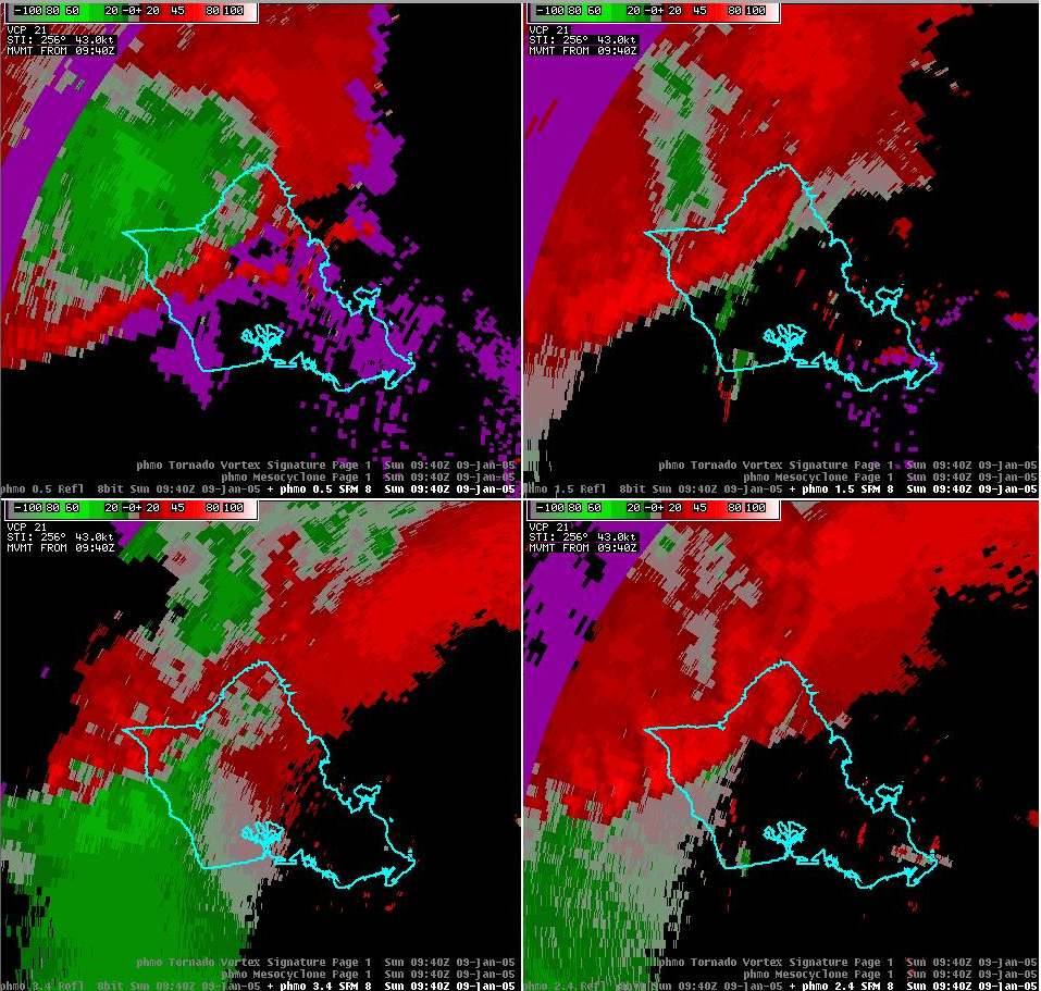
Detailed radar data. Notes: These displays are some of the highly detailed data our meteorologists use to interrogate storms. These views are in a 4 panel such that the lower portion of the storm is in the upper left corner and the highest portion of the storm is in the lower left corner. The reflectivity displays show the intensity of rainfall. As a rough rule of thumb, values over 50 dbz (reds) are very heavy rain, 60 dbz (light purple) indicate hail, over 65 dbz (dark purple) are likely due to large hail. The Storm Relative Velocity (SRM) images indicate winds within the storm. Greens are winds blowing toward the radar, red is away. When red and green are next to each other, that can imply rotation and thus increased chances for tornadoes.
851 pm: Reflectivity SRM Note: Probable initial stages of the development of the Waimea tornado (location given by small box near center of the image)
1035 pm: Reflectivity SRM Note: Well defined bow echo in the Kauai Channel. Probable tornadic waterspout
1140 pm: Reflectivity SRM Note: Most significant part of the bow echo is just a few miles north of Oahu
1256 am: Reflectivity SRM VIL/CR/V/R Note: Redevelopment of line east of Oahu. Yellow triangle at the center denotes the radar detection algorithm signalling for a probable tornado. High reflectivity values signal strong liklihood of large hail.
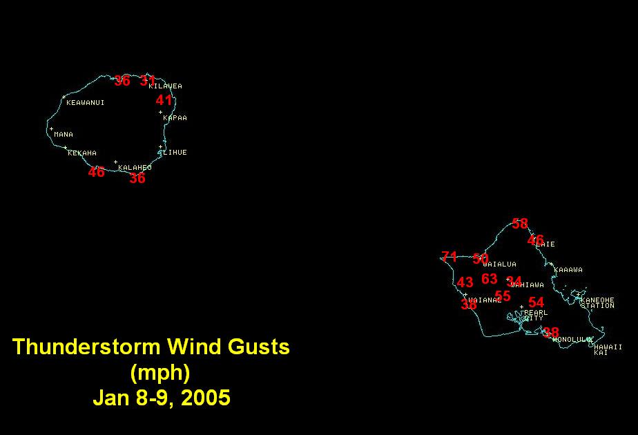
Storm Reports
Peak wind gusts (mph). Asterisks (*) denote readings from "SchoolNet" locations. Map here.
Tornado:
F0 (40-72 mph winds) Waimea Kauai. Carport destroyed. Several trees blown down. Dozens of trees damaged along Menehune Rd and the Waimea River.
Wind Damage:
Kalaheo Kauai. Estimated 60-70 mph straight line winds damaged trees at the National Tropical Botanical Garden
North Shore Oahu. Scattered tree limbs and power outages
Kailua, Oahu. Estimated 60 mph winds caused minor roof and fence damage
Hail:
Reports near Waimea and Kalaheo Kauai. Unknown size.
National Weather Service Watches/Warnings


 Follow us on YouTube