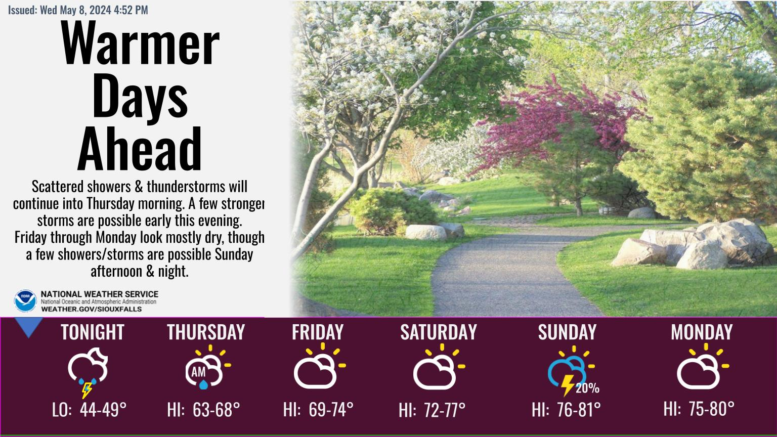
Overview
|
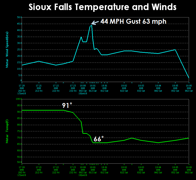
After a hot and humid day across the region, strong thunderstorms moved through during the late afternoon and evening hours. Damaging winds were the most reported weather hazard, with numerous reports of 60+ mph winds. The largest hail report was golf ball size hail near Madison, SD and Parker, SD. Temperatures also fell dramatically as the strong winds and rain moved through. In Sioux Falls, the temperature went from a steamy 90 degrees, down towards a chilly 67 degrees in less than 30 minutes. In many areas there were two rounds of wind from this severe weather event. A strong outflow boundary (cool air rushing away from thunderstorms) would first push through a location bringing 40 to 60 mph winds. This boundary at times, was 30 or miles ahead of thunderstorms. A second round of wind would then accompany the thunderstorm activity as they moved through. The combination of these features led to a long and sustained period of 40 to even 70 mph winds. Heavy rainfall was also common as thunderstorms moved through. Several flash flood warnings were issued with flooding reported in several areas, including the city of Brookings, SD. Localized rainfall totals greater than 2 to even 4 inches were reported. Strong winds and tree damage lead to power outages in many areas. In portions of NW Iowa, including Sioux City, MidAmerican Energy reported that 12,600 customers were without power at one point following the passage of storms. |
 Radar Loop of Friday Evening Storms |
Photos & Video:
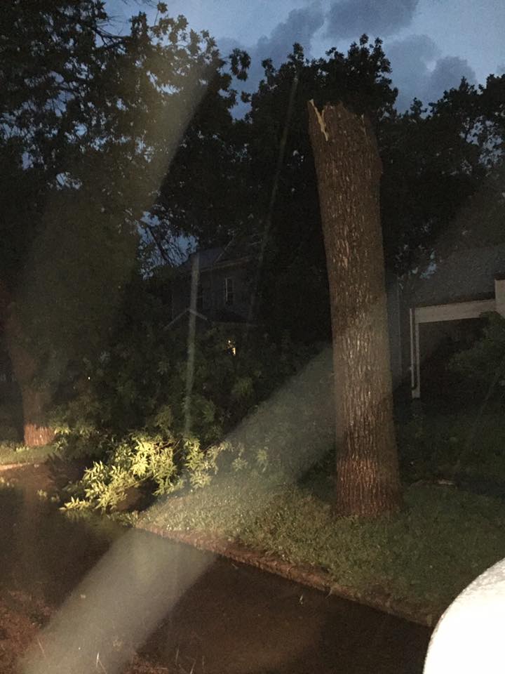
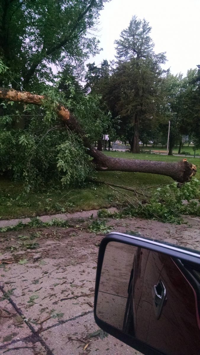
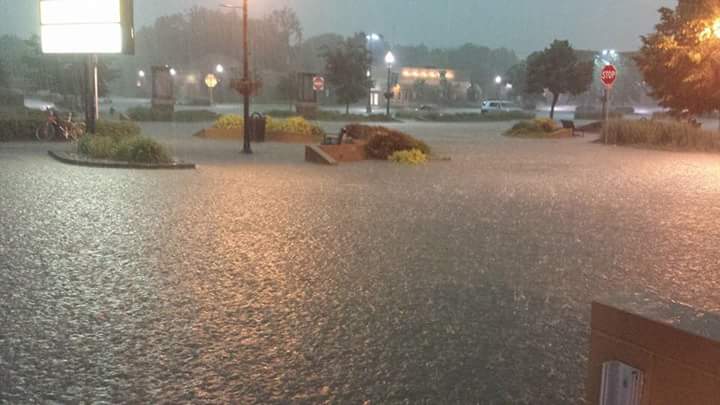
Various Photos of Severe Weather Reports and Information
 |
 |
 |
 |
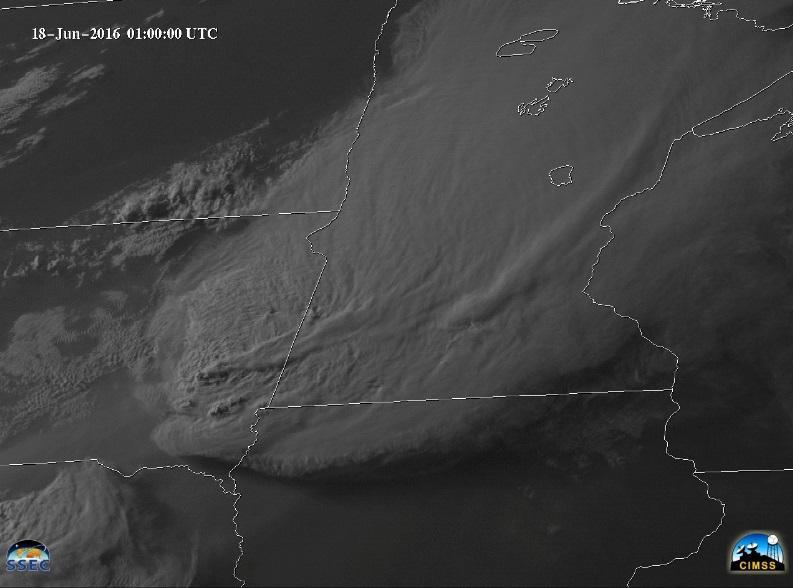
| Satellite Image of Evening Storms SSEC/CIMMS |
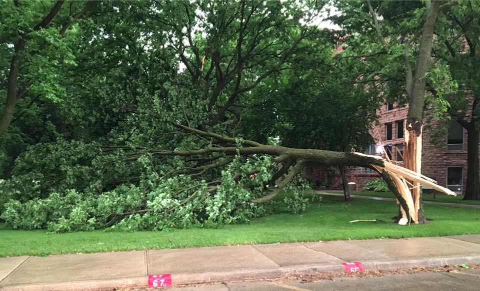
Tree Damage in Madison KJAM Radio |
Hail in Brookings, SD (Jason Sik) |
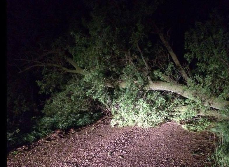
Moody County Tree Damage (Carl Brakke) |
 |
 |
 |
 |
| SiouxFalls Temperature and Wind Speed Trace With Time | Tree Damage in Madison Jacky Unzelman-Vasek |
Lemars Wind Damage (David Skou) |
Brookings Flash Flooding near Childrens Museum (Kellie Rhody) |
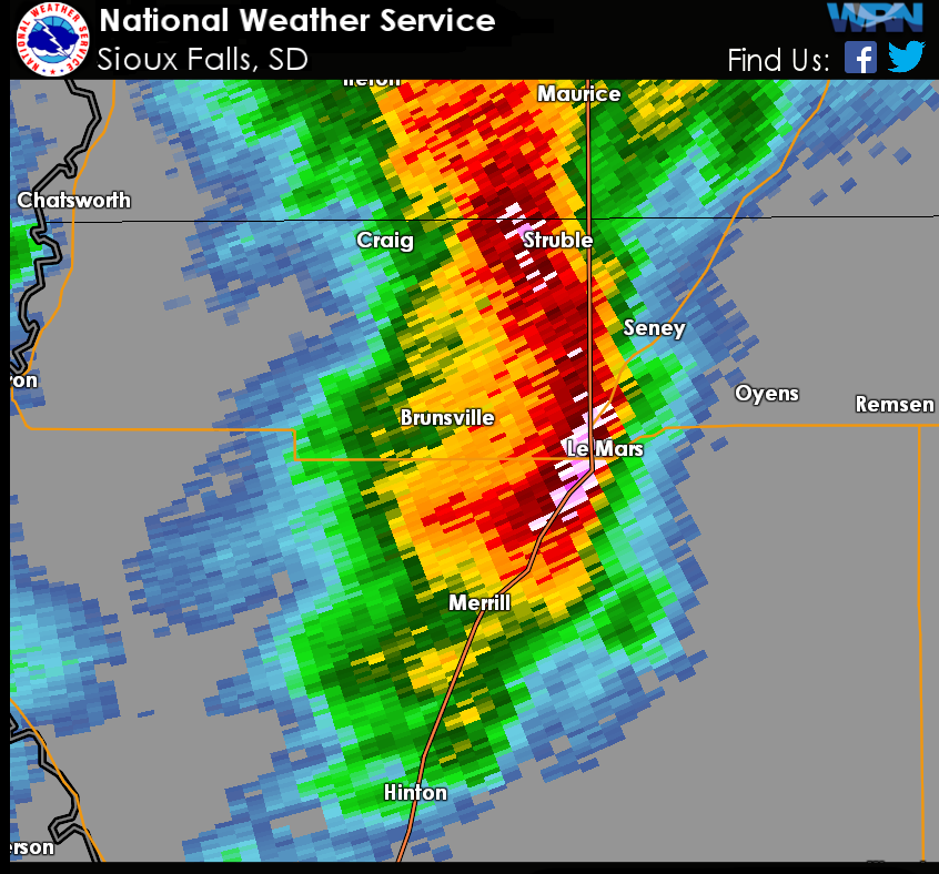
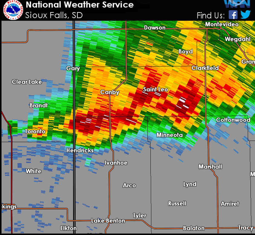
Radar:
|
Additonal Radar Image (More Arriving at a Later Time)
 |
 |
||
| LeMars, IA 940 PM | Minneota 80 MPH Winds 457pm |
Storm Reports (Live and Interactive Display)

| Report Time | County | Location | ST | Event Type | Mag. | Source | Remark |
| Fri Jun 17 2016 15:30:00 GMT-0500 (Central Daylight Time) | Cherokee | 9 S Marcus | IA | TSTM WND DMG | 0 | public | tree down on a machine shed. |
| Fri Jun 17 2016 22:00:00 GMT-0500 (Central Daylight Time) | Lyon | Minneota | MN | TSTM WND GST | 80 | trained spotter | numerous trees down around town . |
| Fri Jun 17 2016 22:01:00 GMT-0500 (Central Daylight Time) | Lyon | Cottonwood | MN | TSTM WND GST | 50 | trained spotter | . |
| Fri Jun 17 2016 22:14:00 GMT-0500 (Central Daylight Time) | Lyon | Marshall | MN | TSTM WND GST | 60 | trained spotter | . |
| Fri Jun 17 2016 22:20:00 GMT-0500 (Central Daylight Time) | Lyon | Marshall | MN | TSTM WND GST | 72 | public | . |
| Fri Jun 17 2016 22:31:00 GMT-0500 (Central Daylight Time) | Lyon | 5 NNW Tracy | MN | TSTM WND DMG | 0 | public | top of a grain elevator damaged. |
| Fri Jun 17 2016 22:40:00 GMT-0500 (Central Daylight Time) | Lyon | Tracy | MN | TSTM WND DMG | 0 | trained spotter | large tree blown down. |
| Fri Jun 17 2016 23:08:00 GMT-0500 (Central Daylight Time) | Brookings | 2 NE Sinai | SD | HAIL | 0.5 | public | . |
| Fri Jun 17 2016 23:12:00 GMT-0500 (Central Daylight Time) | Cottonwood | Mountain Lake | MN | TSTM WND DMG | 0 | emergency mngr | large tree down across road. |
| Fri Jun 17 2016 23:28:00 GMT-0500 (Central Daylight Time) | Jackson | 2 ENE Wilder | MN | TSTM WND GST | 50 | nws employee | . |
| Fri Jun 17 2016 23:40:00 GMT-0500 (Central Daylight Time) | Turner | Parker | SD | HAIL | 1 | public | . |
| Fri Jun 17 2016 23:40:00 GMT-0500 (Central Daylight Time) | Jackson | 3 S Lakefield | MN | TSTM WND GST | 53 | mesonet | . |
| Fri Jun 17 2016 23:49:00 GMT-0500 (Central Daylight Time) | Brookings | Brookings | SD | HAIL | 1.5 | trained spotter | . |
| Sat Jun 18 2016 00:00:00 GMT-0500 (Central Daylight Time) | Brookings | Brookings | SD | FLASH FLOOD | 0 | emergency mngr | several streets are impassable due to high water. |
| Sat Jun 18 2016 00:01:00 GMT-0500 (Central Daylight Time) | Brookings | Brookings | SD | HAIL | 1 | public | report via social media. |
| Sat Jun 18 2016 00:05:00 GMT-0500 (Central Daylight Time) | Dickinson | 1 ENE West Okoboji | IA | TSTM WND DMG | 0 | emergency mngr | 8 inch diameter tree limb down on lakeshore drive. |
| Sat Jun 18 2016 00:18:00 GMT-0500 (Central Daylight Time) | Lake | Madison | SD | HAIL | 1 | trained spotter | . |
| Sat Jun 18 2016 00:21:00 GMT-0500 (Central Daylight Time) | Lake | Madison | SD | HAIL | 1.75 | trained spotter | . |
| Sat Jun 18 2016 00:24:00 GMT-0500 (Central Daylight Time) | Minnehaha | 3 NNW Sioux Falls | SD | TSTM WND GST | 49 | official nws obs | . |
| Sat Jun 18 2016 00:28:00 GMT-0500 (Central Daylight Time) | Dickinson | Spirit Lake | IA | TSTM WND DMG | 0 | emergency mngr | 8-12 inch tree limb down. |
| Sat Jun 18 2016 00:35:00 GMT-0500 (Central Daylight Time) | Minnehaha | Sioux Falls | SD | TSTM WND DMG | 0 | law enforcement | several trees down around town. |
| Sat Jun 18 2016 00:35:00 GMT-0500 (Central Daylight Time) | Lake | Wentworth | SD | TSTM WND DMG | 0 | emergency mngr | large trees down. |
| Sat Jun 18 2016 00:40:00 GMT-0500 (Central Daylight Time) | Brookings | Brookings | SD | FLASH FLOOD | 0 | public | car stuck near 6th street and main avenue. report and photo posted via social media. |
| Sat Jun 18 2016 00:40:00 GMT-0500 (Central Daylight Time) | Minnehaha | Garretson | SD | TSTM WND GST | 50 | emergency mngr | . |
| Sat Jun 18 2016 00:44:00 GMT-0500 (Central Daylight Time) | Minnehaha | Sherman | SD | HAIL | 0.75 | emergency mngr | . |
| Sat Jun 18 2016 01:30:00 GMT-0500 (Central Daylight Time) | Minnehaha | Hartford | SD | TSTM WND DMG | 0 | public | large tree down. report and photo posted via social media. |
| Sat Jun 18 2016 01:30:00 GMT-0500 (Central Daylight Time) | Mccook | Canistota | SD | TSTM WND DMG | 0 | trained spotter | trees down. |
| Sat Jun 18 2016 01:40:00 GMT-0500 (Central Daylight Time) | Sioux | Rock Valley | IA | TSTM WND DMG | 0 | emergency mngr | tree branches down and there was a power outage. |
| Sat Jun 18 2016 01:55:00 GMT-0500 (Central Daylight Time) | Sioux | Hawarden | IA | TSTM WND DMG | 0 | emergency mngr | numerous trees down across the area. |
| Sat Jun 18 2016 02:05:00 GMT-0500 (Central Daylight Time) | Turner | Viborg | SD | TSTM WND DMG | 0 | law enforcement | 2-3 inches tree branches down in viborg and hurley. |
| Sat Jun 18 2016 02:20:00 GMT-0500 (Central Daylight Time) | Hutchinson | Menno | SD | HAIL | 1.25 | law enforcement | trees down around town. |
| Sat Jun 18 2016 02:25:00 GMT-0500 (Central Daylight Time) | Turner | Parker | SD | HAIL | 1.75 | law enforcement | time estimated by radar. |
| Sat Jun 18 2016 02:42:00 GMT-0500 (Central Daylight Time) | Plymouth | Le Mars | IA | TSTM WND GST | 68 | law enforcement | . |
| Sat Jun 18 2016 02:45:00 GMT-0500 (Central Daylight Time) | Plymouth | 5 W Merrill | IA | TSTM WND DMG | 0 | public | shingles blown off. |
| Sat Jun 18 2016 03:10:00 GMT-0500 (Central Daylight Time) | Dixon | Newcastle | NE | TSTM WND DMG | 0 | law enforcement | trees down in the town. |
| Sat Jun 18 2016 03:12:00 GMT-0500 (Central Daylight Time) | Woodbury | Sioux City | IA | TSTM WND GST | 61 | asos | . |
| Sat Jun 18 2016 03:13:00 GMT-0500 (Central Daylight Time) | Plymouth | 2 W Le Mars | IA | TSTM WND DMG | 0 | public | trees down in the area. |
| Sat Jun 18 2016 03:28:00 GMT-0500 (Central Daylight Time) | Plymouth | Kingsley | IA | HAIL | 1 | trained spotter | . |
| Sat Jun 18 2016 03:40:00 GMT-0500 (Central Daylight Time) | Woodbury | Sioux City | IA | TSTM WND GST | 69 | asos | . |
| Sat Jun 18 2016 03:44:00 GMT-0500 (Central Daylight Time) | Woodbury | 5 N Lawton | IA | TSTM WND DMG | 0 | public | large tree down and damage to a barn. |
Rain Reports
|
|
 |
Media use of NWS Web News Stories is encouraged! Please acknowledge the NWS as the source of any news information accessed from this site. |
|


 Weather Story
 Weather Map
 Local Radar
 Follow us on YouTube