Please see our official statement from a damage survey from the National Weather Service in Sioux Falls.
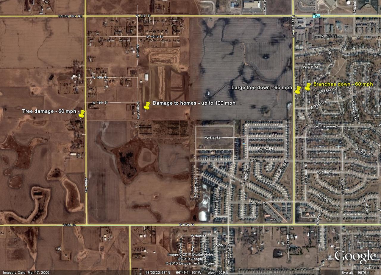
At 2:40 am CDT, a squall line with damaging winds moved through the Sioux Falls area. Winds of 40 to 60 mph were common across the city. However, at least 2 wet microbursts, occurred which caused more significant damage. A wet microburst is an area where winds from aloft in the thunderstorms are accelerated to the surface causing winds of at least 60 mph and at times in excess of 100 mph. One of these wet microbursts caused significant damage to a neighborhood east of Tea-Ellis Road and south of 41st St. Winds in this neighborhood were estimated at 100 mph which is equivalent to an EF-1 tornado. A map of the damage is below.
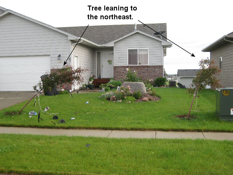
As the storm approached Tea-Ellis Road, there was some tree damage, with large branches down, at a home south of the intersection of Tea-Ellis Road and 48th St. The winds in this area were estimated to be 60 mph. As the line continued to move east, the winds strengthened when a wet microburst occurred east of Tea-Ellis Road. On the western edge of the neighborhood, approximately 1/4 mile east of Tea-Ellis Road, a large pine tree was uprooted - caused by winds of at least 75 mph.
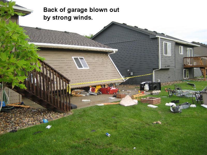
The winds struck the house across the street. The garage down was blown in by winds of around 90 mph. After the garage door gave way, the back wall of the garage was separated from the foundation.
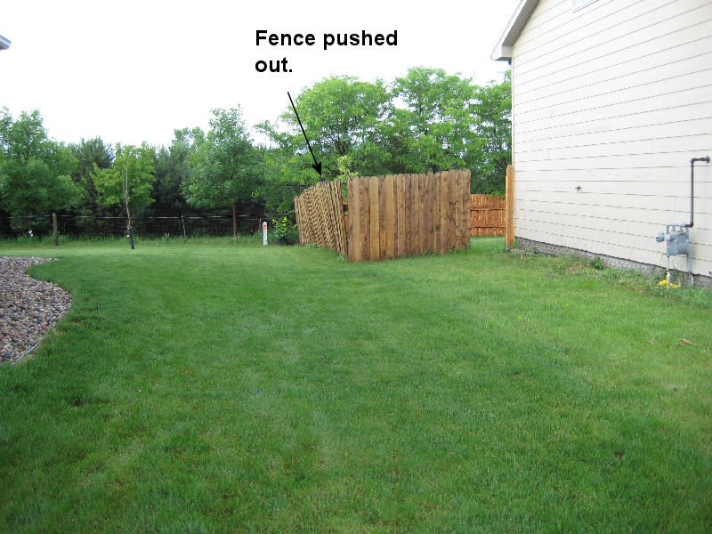
The winds also knocked down the fence in the backyard of the property. Notice that the fence is laying to the east and debris was carried east toward the next house. This indicates that the winds were from the west.
.jpg)
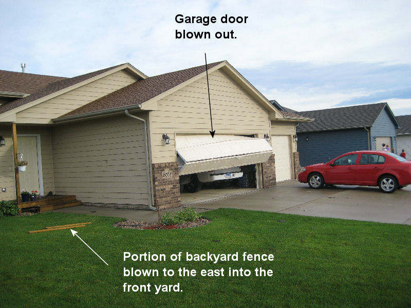
On the east side of the house, the garage door was blown outward by the force of the wind. In addition, portions of the fence were carried to the front of the house. Winds were estimated around 90 mph.
The next door house also had the garage door completely blown outward into the driveway. The suction created by winds around 90 mph sucked insulation out of the attic and into the garage.
.jpg)
As the winds from the microburst moved east, it continued to cause damage. On the southern edge of the strong winds, 60 mph west winds cause a fence to lean to the east.
On the other side of the street, there were a few trees which were bent over to the west by 60 mph. Other than toppling swing sets and damage to trees, the wind did not do significant damage to structures in this area.
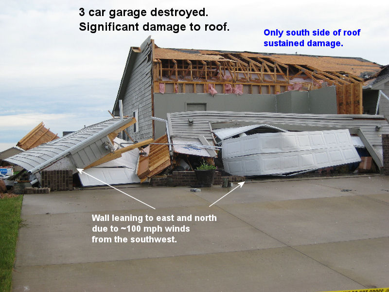
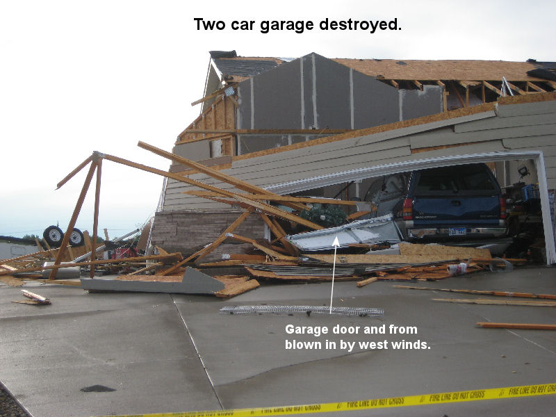
The winds were likely reinforced by another microburst as they continued to move east through the neighborhood. In the eastern half of the neighborhood, homes with a south-facing garage had significant damage. A 3-car garage was destroyed as winds around 100 mph caused the garage door to be blown in. As the door was blown in the west and south wall of the garage were toppled. The south side of the roof was also severely damaged with all shingles lost as well as some of the plywood.
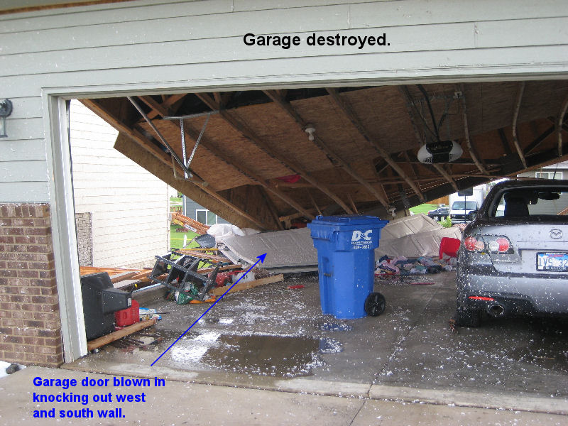
Next door the 100 mph winds also caused the garage door to be blown to the back of the garage. As it did, it likely contributed to the collapse of the west and north wall of the garage. The roof of the garage then collapsed.
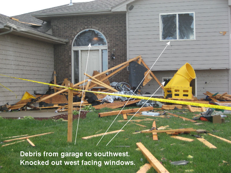
The debris from both garages and roofs was blown at a few hundred feet to the northeast and ended up in this yard. As the debris hit the house, it broke out at least 3 windows and left some plywood on the roof.
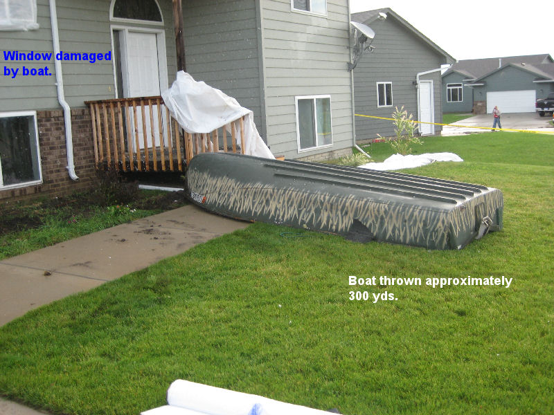
A boat was lifted and blown almost 300 yards and hit the house below. It appears that the boat hit the second story window and broke it before landing near the front step. Winds of at least 75 mph were needed to lift and carry the boat this distance.
On the eastern edge of the neighborhood, a light pole was bent at 90 degrees by the winds. According to the city of Sioux Falls, the light poles were designed to withstand a 90 mph wind.
.jpg)
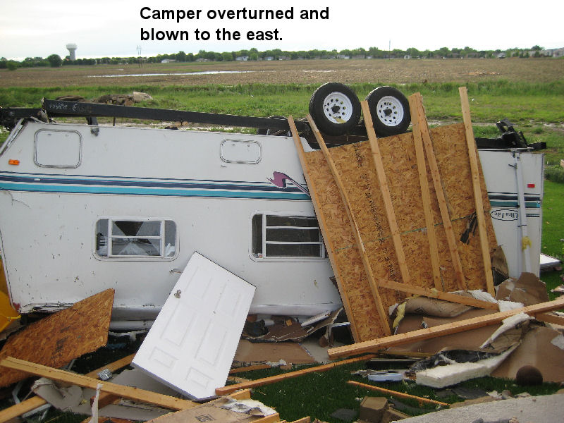
The house below took the brunt of the damaging winds. There was no houses across the street from this house meaning that the winds were likely 100 mph when they hit the front of the house. The 100 mph winds caused the garage door to be blown inward. As the garage door collapsed, the whole west side of the garage wall was blow inward. In addition, there was significant damage to the west side of the roof where almost all shingles and some plywood were taken off. Much of the roof was blown into the field behind the house.
There was also a camper sitting in the driveway. When the 100 mph winds hit the camper, it was overturned and rolled into the backyard of the property.
The debris from the roof was blown several hundred feet across the field by the winds.

The strong winds continued to move east across the field. Fortunately, as they moved east they slowly weakened. Nonetheless winds of 70 mph caused one large tree and several large branches to be snapped east of Sertoma Road south of 46th street. The winds appear to have weakened as they continued east into the city - in part due to the increased number of obstacles such as trees and homes.
The radar reflectivity image below from 2:36 am CDT show that the damage occurred at the leading edge of the squall line with the outflow boundary. Notice that as the storm approached Sioux Falls, there is bulge in the high radar echos (yellow and red colors). This is indicative of very strong winds at the leading edge of the squall line.
.png)
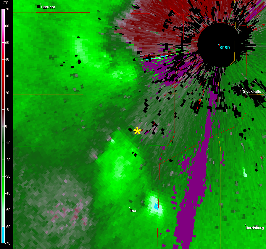
The velocity image from the Sioux Falls radar shows that the radar was estimating winds around 80 mph as they approached the neighborhood (yellow asterick on image). In addition, these winds were associated with a circulation along the squall line. Weather researchers across the country have noted that these type of circulations along squall lines are the focus for extreme winds - sometimes in excess of 100 mph. It was the presence of this circulation in northeastern Turner County that led National Weather Service meteorologists in Sioux Falls to issue a Severe Thunderstorm Warning for the area at 2:24 am CDT. A second circulation to the west of the radar (KFSD in the image) also produced winds of 70 to 90 mph along Russell St including some tree damage at Elmwood Golf Course and to a car dealership near the airport.


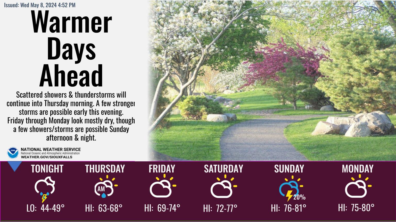 Weather Story
 Weather Map
 Local Radar
 Follow us on YouTube