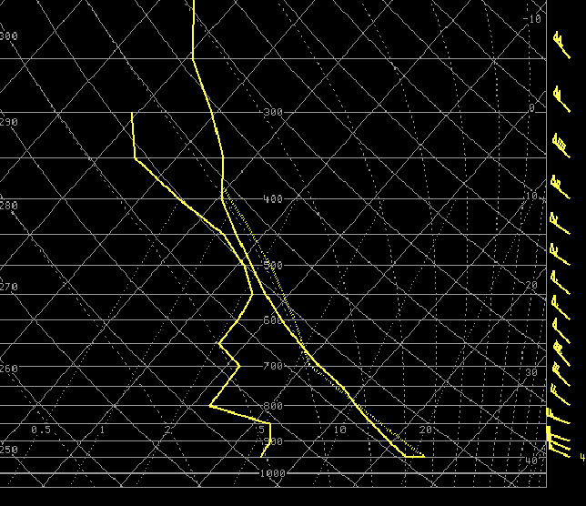
As a strong disturbance pushed southeast across Minnesota on Monday, scattered thunderstorms developed by mid afternoon across eastern South Dakota and southwest Minnesota. Relatively dry air at low levels, combined with a day of strong mid-May surface heating, led to development of what is referred to as an "inverted-V" sounding, named after the upside-down V-shape of the thermodynamic profiles of temperature and dewpoint. These types of soundings typically do not contain a tremendous degree of instability. However, as rain falls into the the very dry layer below the developing storm, the enhanced evaporative cooling of the air creates accelerated sinking motions which can result in very strong winds pushing out from the storm. This was certainly the setup on Monday afternoon, as indicated from the 4 pm CDT Rapid Update Cycle (RUC) analysis sounding from near Sheldon, IA.
A map and listing of the damage reports received as of late Monday evening are given below.

PRELIMINARY LOCAL STORM REPORT...SUMMARY

NATIONAL WEATHER SERVICE SIOUX FALLS SD
1009 PM CDT MON MAY 19 2008

..TIME...   ...EVENT...      ...CITY LOCATION...     ...LAT.LON...
..DATE...   ....MAG....      ..COUNTY LOCATION..ST.. ...SOURCE....
            ..REMARKS..

0455 PM     TSTM WND DMG     4 S SHELDON             43.13N 95.86W
05/19/2008                   O`BRIEN            IA   EMERGENCY MNGR

            HALF OF A ROOF BLOWN OFF A HOG CONFINEMENT. DEBRIS WAS
            SPREAD UP TO ONE HALF MILE DOWNWIND.
0455 PM     TSTM WND GST     SHELDON                 43.18N 95.84W
05/19/2008  M63.00 MPH       O`BRIEN            IA   AWOS
0515 PM     TSTM WND GST     5 WSW ROYAL             43.02N 95.37W
05/19/2008  E60.00 MPH       CLAY               IA   TRAINED SPOTTER

            LOTS OF FLYING DIRT
0535 PM     TSTM WND GST     STORM LAKE              42.65N 95.20W
05/19/2008  M62.00 MPH       BUENA VISTA        IA   AWOS
0540 PM     TSTM WND GST     TRUESDALE               42.73N 95.18W
05/19/2008  E60.00 MPH       BUENA VISTA        IA   FIRE DEPT/RESCUE
0550 PM     TSTM WND DMG     S NEWELL                42.60N 95.00W
05/19/2008                   BUENA VISTA        IA   TRAINED SPOTTER

            LARGE TREE DOWN ON FENCE


 Weather Story
 Weather Map
 Local Radar
 Follow us on YouTube