 |
 |
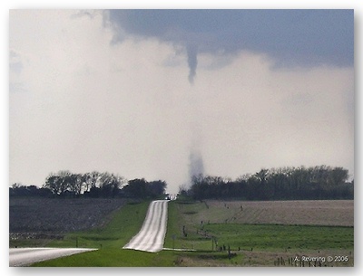
During the early evening, a tornado touched down in the northeast portion of Kingsbury County South Dakota. The tornado was on the ground for at least 6 minutes. No injuries were reported with the tornado, although some livestock were killed as the tornado destroyed some farm outbuildings. A detailed look at the damage produced by the tornado, along with a discussion of the radar imagery and storm-scale meteorological environment, can be found by following the links below.
PUBLIC INFORMATION STATEMENT
NATIONAL WEATHER SERVICE SIOUX FALLS SD
323 PM CDT WED MAY 3 2006
...MAY 2 KINGSBURY COUNTY TORNADO RATED F1 ON FUJITA SCALE...
AN ONSITE DAMAGE SURVEY BY METEOROLOGISTS FROM NATIONAL WEATHER
SERVICE SIOUX FALLS HAS RESULTED IN AN F1 RATING FOR THE TORNADO
THAT TOUCHED DOWN IN KINGSBURY COUNTY ON MAY 2 2006. THE MAXIMUM
WIND SPEED WAS ESTIMATED TO BE AROUND 100 MPH...AS THE TORNADO
DESTROYED TWO HOG SHEDS FOUR MILES NORTH OF LAKE PRESTON SOUTH
DAKOTA...IN KINGSBURY COUNTY.
THE TORNADO FIRST TOUCHED DOWN AT APPROXIMATELY 619 PM...REMAINING
ON THE GROUND FOR 2.1 MILES AS IT MOVED EAST SOUTHEAST...4 MILES
NORTH OF LAKE PRESTON. THE TORNADO LIFTED AROUND 626 PM. THE
MAXIMUM WIDTH OF THE TORNADO IS ESTIMATED TO BE AROUND 100 YARDS
WIDE.
$$
GREG HARMON
METEOROLOGIST IN CHARGE
NWS SIOUX FALLS