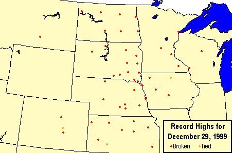
(see table below for listing of individual cities and records)
Dozens of record highs were set across the Northern and Central Plains on Wednesday, December 29, 1999. In many cases, the previous records were not only exceeded, but were obliterated. And a number of the previous records had stood for nearly a century. What caused all this record warmth? The short answer is several factors. Read on for the details.
The synoptic weather pattern for Wednesday the 29th featured a large high pressure system over the Pacific Northwest and low pressure moving southeast along the Minnesota and Canadian border. This set up a broad west to northwesterly flow of dry, unusually mild Pacific air across the area, but this alone would not normally lead to a record event of this scale. What made this pattern a record breaker is that it had been persistent across the region for a couple of days, greatly reducing or eliminating the already limited snow cover across the plains. In the western plains and western Canada, a real dearth of snow cover existed for this time of year. Therefore the mild air associated with the high pressure in the Pacific Northwest, was allowed to proceed downslope from the Rockies over a dry and relatively warm ground. Air moving downhill gets compressed, and since compression is a heating process, the air is warmed further. Usually in the Wintertime, cold storm systems constantly move southeastward from Canada, drawing Arctic air southward and knocking down the temperatures, especially across the eastern plains. As a result, the mild air does not get a chance to become entrenched long enough to produce record highs of this proportion. But in this case, the jet stream flowed unusually far north and east, keeping the cold air pinned into northern and eastern Canada, and allowing record breaking warmth to grab a firm hold on the Northern and Central Plains.
Record High Temperatures for December 29, 1999 |
|||||||
|---|---|---|---|---|---|---|---|
| City | New | Old | Year | City | New | Old | Year |
| Billings, MT | 61 | 59 | 1980 | La Crosse, WI | 53 | 46 | 1908 |
| Bismarck, ND | 55 | 54 | 1890 | Wausau, WI | 44 | 43 | 1979 |
| Devils Lake, ND | 47 | 41 | 1965 | Carroll, IA | 49 | 48 | 1965 |
| Fargo, ND | 52 | 44 | 1897 | Des Moines, IA | 58 | 56 | 1936 |
| Grand Forks, ND (Airport) | 49 | 33 | 1965 | Mason City, IA | 47 | 47 | 1929 |
| Grand Forks, ND (WSO) | 48 | 45 | 1904 | Sioux City, IA | 61 | 59 | 1937 |
| Jamestown, ND | 52 | 45 | 1897 | Spencer, IA | 53 | 50 | 1929 |
| Minot, ND | 52 | 45 | 1929 | Grand Island, NE | 68 | 64 | 1937 |
| Williston, ND | 50 | 45 | 1956 | Hastings, NE | 65 | 58 | 1956 |
| Aberdeen, SD | 59 | 48 | 1929 | Kearney, NE | 65 | 59 | 1949 |
| Academy, SD | 61 | 59 | 1929 | Lincoln, NE | 64 | 62 | 1929 |
| Brookings, SD | 52 | 47 | 1929 | Norfolk, NE | 62 | 61 | 1937 |
| Faith, SD | 56 | 54 | 1956 | North Platte, NE | 66 | 62 | 1929 |
| Huron, SD | 59 | 52 | 1898 | Omaha, NE | 61 | 59 | 1937 |
| Mitchell, SD | 58 | 55 | 1900 | Valentine, NE | 63 | 62 | 1890 |
| Mobridge, SD | 55 | 49 | 1965 | Chanute, KS | 69 | 66 | 1984 |
| Sioux Falls, SD | 56 | 47 | 1929 | Concordia, KS | 66 | 63 | 1929 |
| Vermillion, SD | 60 | 54 | 1929 | Dodge City, KS | 73 | 73 | 1875 |
| Watertown, SD | 53 | 45 | 1929 | Garden City, KS | 74 | 63 | 1951 |
| Winner, SD | 63 | 59 | 1965 | Goodland, KS | 65 | 63 | 1996 |
| Yankton, SD | 62 | 56 | 1890 | Hill City, KS | 67 | 65 | 1984 |
| Duluth, MN | 46 | 42 | 1896 | Russell, KS | 73 | 64 | 1956 |
| Intl Falls, MN | 36 | 36 | 1965 | Salina, KS | 71 | 65 | 1984 |
| Minneapolis, MN | 53 | 44 | 1908 | Topeka, KS | 70 | 68 | 1984 |
| Rochester, MN | 46 | 42 | 1936 | Colorado Springs, CO | 64 | 64 | 1956 |
| St. Cloud, MN | 52 | 42 | 1929 | Pueblo, CO | 71 | 69 | 1919 |
| Wheat Ridge, CO | 67 | 66 | 1955 | ||||


 Weather Story
 Weather Map
 Local Radar
 Follow us on YouTube