National Weather Service United States Department of Commerce

mesowest sample map


MesoNet (Dense Network of Real-Time Observations)

alternate link: Aviation Weather Center

Maps link

Local Images/Maps of the current conditions (temperature, wind, etc.)

Forecaster's
Discussion:

County-by-County
Forecast:

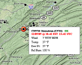
Daily Co-operative Station
Observation Summary:

Public Information
Statement:

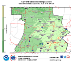
Hourly Weather Roundup for Pennsylvania

Twice-Daily (830 AM/PM) Summary of Weather Conditions

All NWS State College Text Statements/Forecasts:


Satellite Pictures:

Sat Pic

GOES-East Imagery


Radar Images:

KCCX Radar Image
KCCX - Central PA

Regional

Nationwide

Atmospheric Soundings (balloon observations):


UCAR in Boulder, CO (map)


Univ of Wyoming (Text bulletins and recent-past data)

Current Observations for Individual Sites:

Decoded Observations
Raw METARs
Altoona/Blair Co. Airport KAOO
Bradford Reg. Airport KBFD
Clearfield Airport KFIG
Du Bois/ Jefferson Co. Airport KDUJ
Harrisburg (Middletown) Int'l Airport KMDT
Harrisburg (Capital City) Airport KCXY
Johnstown/Cambria Co. Airport KJST
Lancaster Airport KLNS
Selinsgrove (Penn Valley) Airport KSEG
State College (Univ. Park) Airport KUNV
Williamsport/Lycoming Co. Airport KIPT
York (Thomasville) Airport KTHV
 

Meteorological Conversion Utilities
(from NWS St. Louis, MO)

Satellite-based snow depth estimates over the region.
(Includes an interactive map)


All NWS State College Text Statements/Forecasts: