 |
 |
 |
Alex began as a strong tropical wave in the eastern Caribbean Sea on June 20th, 2010. Alex was officially designated as a Tropical Depression on Friday June 25th as it moved into the central Caribbean. Alex became the first Tropical Storm of the season on June 26th, and strengthened to a strong tropical storm with maximum sustained winds of 65 mph before making landfall in the country of Belize. Alex weakened to a tropical depression as it crossed the Yucatan Peninsula, but quickly regained strength in the warm waters of the Gulf of Mexico. For several days leading up to the final landfall, the National Hurricane Center predicted Alex could strengthen into a Category 2 hurricane and make landfall anywhere from the northeast Mexico coast to the Middle Texas coast.
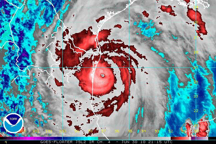
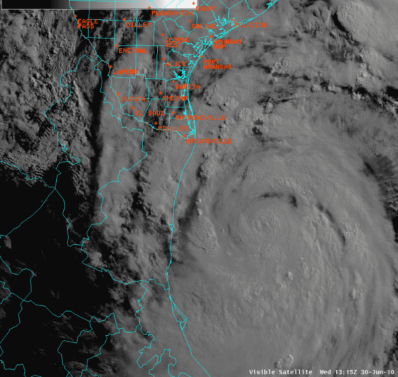
Alex made its final landfall at 9pm, Wednesday June 30th, along the northern Mexican coast around 110 miles south of Brownsville as a Category 2 storm with maximum sustained winds of 105 mph. Alex was the first Hurricane in June for the Altantic Basin since 1995, and the strongest in the month of June since Hurricane Alma in 1966. Alex was a very large hurricane with tropical storm force winds extending over 200 miles from the center. Although Alex passed over 200 miles south of Corpus Christi, tropical storm force wind gusts were measured as far north as Port O'Connor, George West, and Cotulla. The strongest winds were observed on the barrier island from Port Aransas to Baffin Bay where peak wind gusts exceeded 60 mph.
Overall, the impacts to the Middle Texas coast were minimal. Storm tides peaked just below 4 feet mean sea level at tide stations along the coast producing flooding along area beaches. About a half dozen tornadoes occurred within the outer rain bands from Alex. These tornadoes caused mostly minor tree damage. Radar indicated the possibility of several more tornadoes, however NWS survey teams were unable to locate any additional damage. Heavy rainfall and flooding proved to be the biggest impact. Rainfall totals of 3 to 6 inches with isolated amounts near 10 inches were observed across South Texas. This resulted in flooding of many roads and farm fields from Alice to Sinton.
|
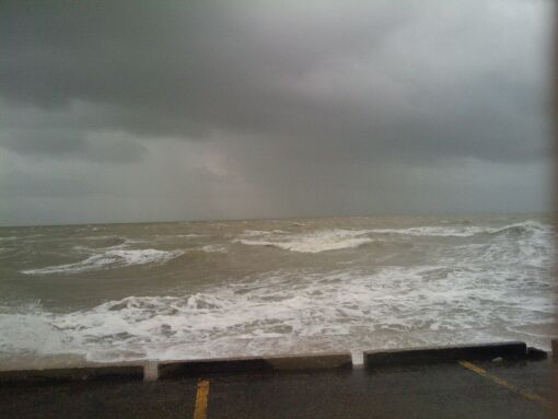
Corpus Christi Bay on June 30th prior to Alex making landfall |
|
KBRO Radar Reflectivity loop beginning at 704 PM CDT on 06/30/10 and ending at 701 AM CDT on 07/01/10. |
|
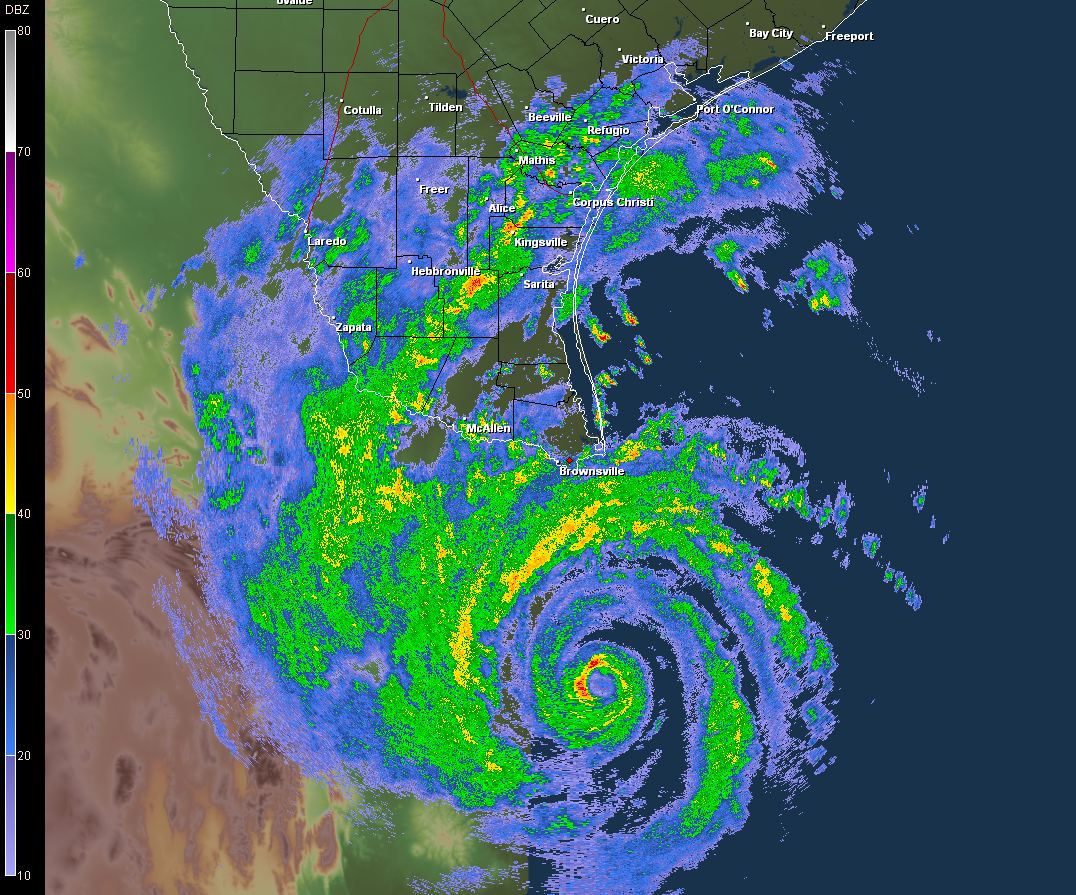
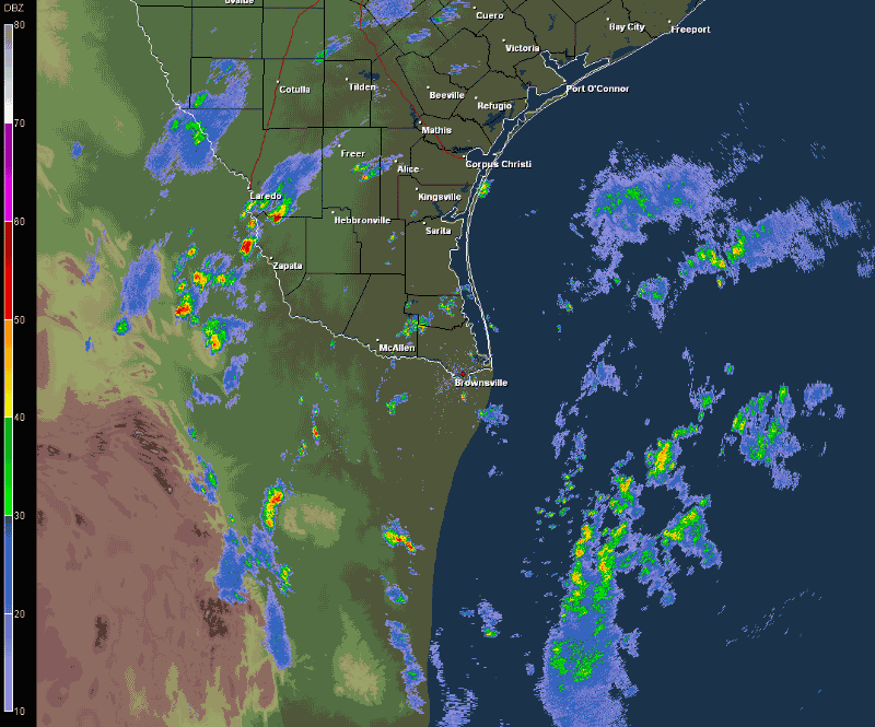
KCRP Radar Reflectivity loop beginning at 904 AM CDT on 06/30/10 and ending at 1140 PM CDT on 06/30/10. |
|
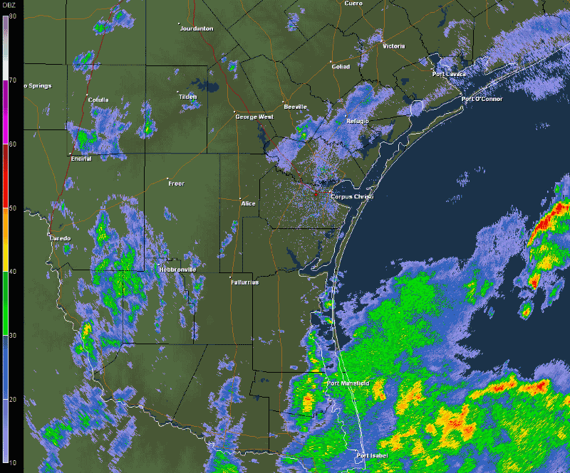
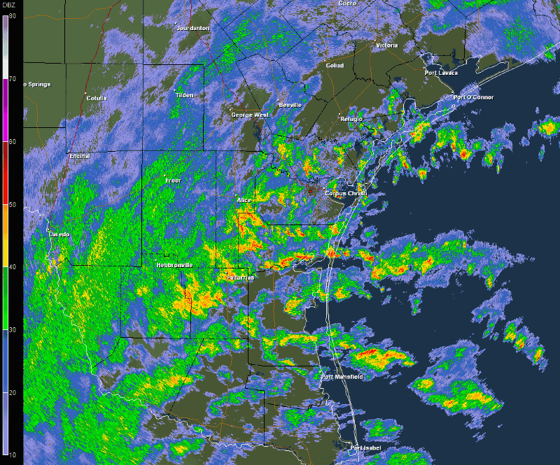
KCRP Radar Reflectivity loop beginning at 1203 AM CDT on 07/01/10 and ending at 1159 PM CDT on 07/01/10. |
|
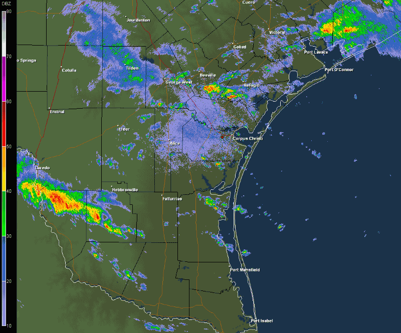
KCRP Radar Reflectivity loop beginning at 1226 AM CDT on 07/02/10 and ending at 659 PM CDT on 07/02/10. |
|
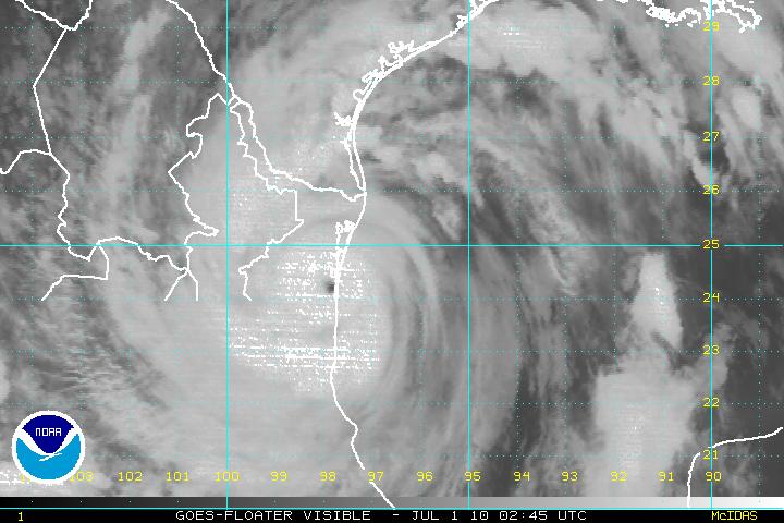
Visible Satellite loop beginning at 815 AM CDT on 06/30/10 and ending at 510 PM CDT on 06/30/10. |
|
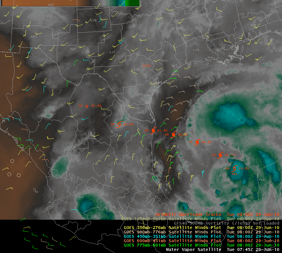
GOES water vapor loop depicting satellite derived winds and moisture. This loop depicts the life-cycle of Alex when it moved off of the Yucatan starting 2 am CDT June 29.
|
...TIME...   ...EVENT...      ...CITY LOCATION...     ...LAT.LON...
..DATE...   ....MAG....      ..COUNTY LOCATION..ST.. ...SOURCE....
            ..REMARKS..

1146 AM     TORNADO          11 SW TIVOLI            28.33N 97.02W
06/30/2010  F0               REFUGIO            TX   PARK/FOREST SRVC

            A TORNADO WAS OBSERVED IN AN OPEN FIELD NORTHWEST OF THE
            ARANSAS WILDLIFE REFUGE BY PARK OFFICIALS. A NWS STORM
            SURVEY INDICATED THE TORNADO WAS ESTIMATED TO BE ON THE
            GROUND FOR 7 MILES AS IT MOVED WEST-SOUTHWEST OVER OPEN
            COUNTRY, JUST NORTH OF FM 774.

0124 PM     FUNNEL CLOUD     6 NNE ROBSTOWN          27.88N 97.62W
06/30/2010                   NUECES             TX   LAW ENFORCEMENT

            FUNNEL CLOUD REPORTED NEAR LABONTE PARK

0230 PM     TORNADO          9 WNW ROBSTOWN          27.83N 97.80W
06/30/2010  F0               NUECES             TX   NWS STORM SURVEY

            A NWS STORM SURVEY TEAM FOUND EVIDENCE OF A BRIEF TORNADO
            TOUCHDOWN ALONG FM 666, BETWEEN BANQUETE AND CR 44. A
            TELEPHONE LINE WAS PULLED DOWN TO THE GROUND BY SEVERAL
            MESQUITE TREES THAT WERE ALMOST UPROOTED. WINDS WERE
            ESTIMATED TO BE AROUND 65 MPH. THE TORNADO HAD A WIDTH OF
            ROUGHLY 30 YARDS AND A PATH LENGTH OF 50-100 YARDS.

0310 PM     TORNADO          5 N BAYSIDE             28.15N 97.24W
06/30/2010  F0               REFUGIO            TX   LAW ENFORCEMENT

            ARANSAS COUNTY RECEIVED PUBLIC REPORTS OF A TORNADO NEAR
            BAYSIDE

0941 PM     TORNADO          1 NE HOLIDAY BEACH      28.14N 96.98W
06/30/2010  F0               ARANSAS            TX   NWS STORM SURVEY

            A NWS STORM SURVEY CONFIRMED A TORNADO TOUCHED DOWN JUST
            OUTSIDE OF GOOSE ISLAND STATE PARK AND MOVED SOUTHWEST
            INTO THE PARK. MEDIUM TO LARGE TREE LIMBS WERE SNAPPED
            ALONG A PATH ROUGHLY 1/2 MILE.

0134 AM     FLOOD            KINGSVILLE              27.51N 97.86W
07/01/2010                   KLEBERG            TX   EMERGENCY MNGR

            MOST OF THE SIDE STREETS IN KINGSVILLE ARE INUNDATED WITH
            WATER OVER THE CURBS. BARELY PASSABLE THROUGH THE CENTER
            OF THE STREETS. EM IS CONCERNED THAT OTHER ROADWAYS
            ACROSS THE COUNTY MAY BE TOTALLY IMPASSABLE.

0755 AM     FLOOD            7 SE ALICE              27.68N 97.98W
07/01/2010                   JIM WELLS          TX   LAW ENFORCEMENT

            SEVERAL ROADS CLOSED, INCLUDING CR 433, CR 382, CR211,
            AND FM 1352 AND 2508

0839 AM     FLASH FLOOD      BISHOP                  27.58N 97.80W
07/01/2010                   NUECES             TX   EMERGENCY MNGR

            RAINFALL TOTAL OF 4.62 INCHES CAUSING FLOODING OF STREETS
            AROUND TOWN...HOWEVER ROADS ARE PASSIBLE.

0900 AM     HEAVY RAIN       8 WNW ORANGE GROVE      27.99N 98.07W
07/01/2010  M0.00 INCH       JIM WELLS          TX   CO-OP OBSERVER

            3.5 INCHES OF RAIN MEASURED SINCE 630 AM...AND STILL
            RAINING. COCORAHS OBSERVER.

0920 AM     HEAVY RAIN       6 WNW ORANGE GROVE      27.99N 98.03W
07/01/2010  M4.52 INCH       JIM WELLS          TX   TRAINED SPOTTER

            COCORAHS OBSERVATION MEASURED IN 3 HOURS FROM 630AM TO
            920AM.

0920 AM     TORNADO          2 S ROCKPORT            28.00N 97.07W
07/01/2010  F0               ARANSAS            TX   PUBLIC

            CITIZEN AND FIRE OFFICIAL REPORT OF A TORNADO WHICH
            BRIEFLY TOUCHED DOWN AT THE INTERSECTION OF 9TH STREET
            AND BUSINESS 35. WINDOWS WERE BLOWN OUT OF THE KIMCO
            BUSINESS.

0355 PM     FUNNEL CLOUD     FREER                   27.88N 98.62W
07/01/2010                   DUVAL              TX   EMERGENCY MNGR

            SEVERAL FUNNEL CLOUDS WERE REPORTED HALFWAY TO THE GROUND
            JUST WEST OF FREER.

0610 PM     TORNADO          9 NW KINGSVILLE         27.60N 97.96W
07/01/2010                   KLEBERG            TX   TRAINED SPOTTER

            A TORNADO WAS REPORTED BY A SKYWARN SPOTTER 9 MILES NW OF
            KINGSVILLE.

0634 PM     FUNNEL CLOUD     1 N BEN BOLT            27.65N 98.08W
07/01/2010                   JIM WELLS          TX   STORM CHASER

            STORM CHASER REPORTED A FUNNEL CLOUD JUST NORTH OF BEN
            BOLT.

0640 PM     FLOOD            8 SSW ALICE             27.65N 98.12W
07/01/2010                   JIM WELLS          TX   TRAINED SPOTTER

            COUNTY ROAD NEAR HOUSE IS FLOODED. CARS MAKING IT THROUGH
            VERY SLOWLY. CREEK 200 YRDS WEST OF OBSERVER OVERFLOWING
            BANK WHICH HAS FLOODED THE ADJACENT FIELD.

0812 PM     FLASH FLOOD      PORTLAND                27.88N 97.33W
07/01/2010                   SAN PATRICIO       TX   BROADCAST MEDIA

            WILDCAT DRIVE FROM LANG ROAD TO MEMORIAL PARKWAY IS
            FLOODED.

0235 PM     FLOOD            BEEVILLE                28.41N 97.75W
07/02/2010                   BEE                TX   LAW ENFORCEMENT

            HEAVY RAIN MINOR WATER ON ROUTE 888, 59 WEST AND FM 351.
            RADAR DEPICTED 3-4 INCH HOURLY RAIN RATES.

0443 PM     FLOOD            CHARCO                  28.73N 97.63W
07/02/2010                   GOLIAD             TX   TRAINED SPOTTER

            OBSERVER REPORTS 3.5 INCHES IN 1.5 HOURS. STANDING WATER
            ON PROPERTY AND NEARBY ROAD. VEHICLES ABLE TO DRIVE
            THROUGH WATER...BUT VERY CAUTIOUSLY.
|
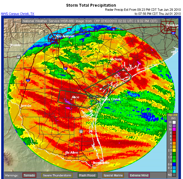
Storm Total Rainfall for Alex |
|
Radar-based storm total precipitation ending 932 pm Thursday July 1 |
|
Rainfall Location |
Inches |
Wind Location |
Peak Wind (mph) |
|---|---|---|---|
| Orange Grove | 9.79 | Baffin Bay | 64 |
| Sea Drift | 8.61 | Port Aransas | 61 |
| Bishop | 8.28 | S Bird Island | 56 |
| Alice Airport | 8.19 | Packery Ch | 56 |
| Odem | 7.43 | Bob Hall Pier | 54 |
| Concepcion | 7.34 | Corpus Naval | 52 |
| Encinal | 6.83 | Cotulla | 49 |
| Ingleside | 6.76 | Port O'Connor | 48 |
| Woodsboro | 6.73 | Rockport | 46 |
| Rockport | 6.64 | Cabaniss Field | 46 |
| Port Lavaca | 6.54 | Corpus Christi | 44 |
| Corpus Christi Arpt | 6.22 | Nueces Bay | 42 |
| Calallen | 6.09 | Laredo | 39 |
| Bloomington | 6.05 | Alice | 37 |
| Rainfall Totals from June 29 through July 2 morning and the Peak Wind Gusts during Alex |


 Follow us on YouTube