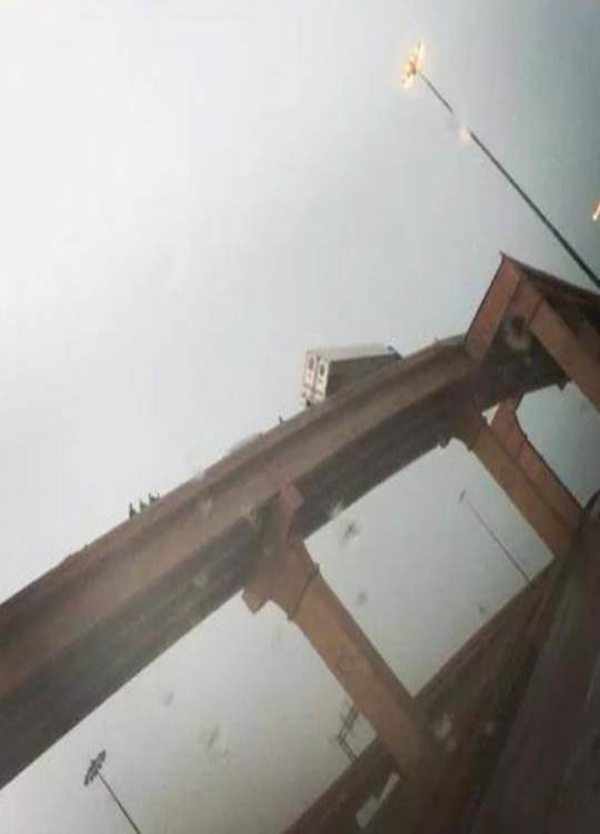
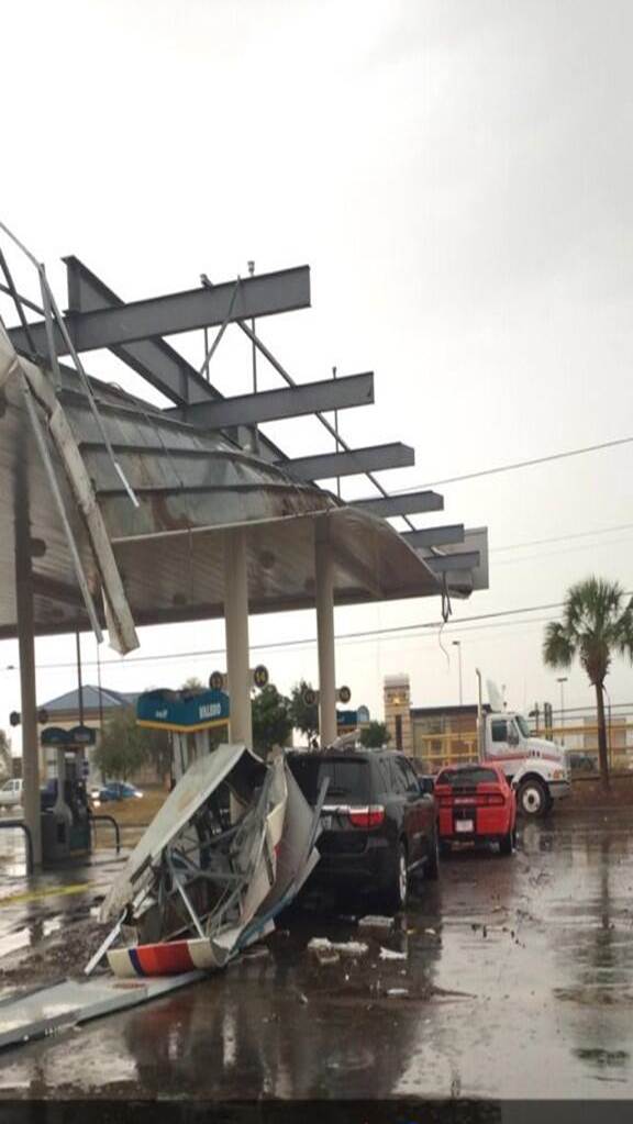
Abundant moisture, a very unstable airmass, and a favorable upper level situation combined to produce severe weather and heavy rain across South Texas on Friday. Early in the day, some convergence through the Coastal Bend brought several rounds of non-severe storms to areas from Corpus Christi Bay southward. Later in the day, as temperatures warmed in the west, available energy increased significantly, and as the upper level jet moved across the area, stronger storms were able to develop. The thunderstorms weakened in the evening as daytime heating ended and the upper level jet began to move out of the area.
Here's a loop of the main action as convection rolling off the Sierra Madre mountains collided with the existing convection and merged into a mesoscale convective system (MCS).

This radar loop shows the initial convection over La Salle and McMullen Counties colliding with convection coming off the mountains, then racing to the coast. Toward the end you can see the line lose strength due to the loss of daytime heating and a weak marine inversion.
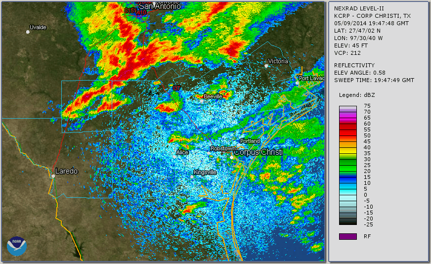
Many locations in South Texas got beneficial rain in this event. Some locations received more than 3.5 inches of rain! Here is a rainfall map that combines radar estimates with actual rainfall totals reported from our cooperative observers:

  STATION                         HI   LO  OBS    PCPN


...VICTORIA CROSSROADS AREA...
COLETO CREEK                      81   63   65    0.94
VICTORIA FIRE DEPT                83   63   63    0.28


...COASTAL COUNTIES...
AUSTWELL                          79   68   71    0.25
CC BOTANICAL GARDENS              75   64   66    0.94
CORPUS CHRISTI NWS                78   64   65    2.61
KINGSVILLE (CITY)                 89   64   67    1.80
MATHIS 4SSW                       81   64   65    0.75
PADRE ISLAND                      74   65   74    1.85
PORT ARANSAS 11 SSW               75   66   72    0.97
PORTLAND                                          1.51
PORT LAVACA                       80   67   76    0.51
ROBSTOWN                                          1.40


...INLAND COUNTIES...
CALLIHAM                          82   61   63    0.82
CHOKE CANYON                      80   61   61    1.16
CROSS                             88   62   63    1.32
FREER                             89   61   61    1.33
LAREDO (HEATWAVE)                 97   66   71    1.12
THREE RIVERS 8NE                                  1.11
TXAR08  : ARANSAS PASS 6.1 NNW     *   : 0.55 /
TXRF02  : AUSTWELL 0.3 ESE         *   : 0.25 /
TXBEE18 : BEEVILLE 9.0 S           *   : 0.49 /
TXGD16  : BEEVILLE 12.6 NNE        *   : 0.72 /
TXLO05  : CHOKE CANYON DAM NORTH SI*   : 1.65 /
TXLO08  : CLEGG 0.1 S              *   : 1.49 /
TXNU38  : CORPUS CHRISTI 4.8 W     *   : 3.58 /
TXNU18  : CORPUS CHRISTI 6.1 WSW   *   : 1.00 /
TXNU45  : CORPUS CHRISTI 6.7 WSW   *   : 1.00 /
TXLS09  : COTULLA 9.7 NNE          *   : 0.04 /
TXLS03  : DILLEY 17.9 ESE          *   : 0.12 /
TXWB23  : FREER 29.5 WSW           *   : 0.88 /
TXLO02  : GEORGE WEST 0.1 WSW      *   : 1.03 /
TXLO09  : GEORGE WEST 2.7 NNW      *   : 1.23 /
TXLO16  : GEORGE WEST 11.3 S       *   : 1.04 /
TXGD06  : GOLIAD 0.4 NW            *   : 0.20 /
TXGD03  : GOLIAD 2.4 SE            *   : 0.18 /
TXGD08  : GOLIAD 4.1 NW            *   : 0.24 /
TXGD19  : GOLIAD 10.9 NE           *   : 0.10 /
TXGD04  : GOLIAD 14.5 WNW          *   : 1.90 /
TXSP13  : INGLESIDE 1.7 SW         *   : 0.95 /
TXKL11  : KINGSVILLE 0.6 E         *   : 1.77 /
TXKL02  : KINGSVILLE 6.5 SSE       *   : 2.10 /
TXWB12  : LAREDO 1.8 N             *   : 0.85 /
TXWB06  : LAREDO 2.4 S             *   : 1.45 /
TXWB47  : LAREDO 2.5 N             *   : 0.68 /
TXWB41  : LAREDO 8.4 NNW           *   : 1.17 /
TXLO19  : MATHIS 12.3 NW           *   : 0.48 /
TXBEE17 : NORMANNA 0.5 ENE         *   : 0.70 /
TXJW05  : ORANGE GROVE 4.3 SW      *   : 0.79 /
TXJW03  : ORANGE GROVE 8.1 WNW     *   : 0.85 /
TXJW08  : PALITO BLANCO 1.0 ESE    *   : 3.23 /
TXSP18  : PORTLAND 1.3 NW          *   : 1.58 /
TXAR03  : ROCKPORT 2.1 NNW         *   : 0.56 /
TXAR06  : ROCKPORT 3.0 NNW         *   : 0.65 /
TXCLH09 : SEADRIFT 0.6 E           *   : 0.22 /
TXCLH15 : SEADRIFT 4.9 ENE         *   : 0.16 /
TXCLH01 : SEADRIFT 5.1 E           *   : 0.20 /
TXLO13  : THREE RIVERS 8.6 NNE     *   : 0.62 /
TXMCM04 : TILDEN 16.0 NNW          *   : 0.35 /
TXVC04  : VICTORIA 1.3 E           *   : 1.14 /
TXVC10  : VICTORIA 1.6 W           *   : 0.60 /
TXVC05  : VICTORIA 1.7S            *   : 0.55 /
TXVC17  : VICTORIA 2.1 NNW         *   : 0.39 /
TXVC20  : VICTORIA 9.7 ESE         *   : 0.67 /
TXVC03  : VICTORIA 11.9 SE         *   : 1.19 /
TXGD15  : WESER 1.9 NW             *   : 0.30 /
TXRF03  : WOODSBORO 3.6 S          *   : 0.64 /


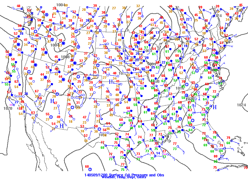
A strong surface low over the Great Lakes region had an associated cold front across the midwest and stalles over north Texas. Southeast wind over South Texas had pooled very moist air over the region. Dewpoints at 7am were in the lower to mid 70s.
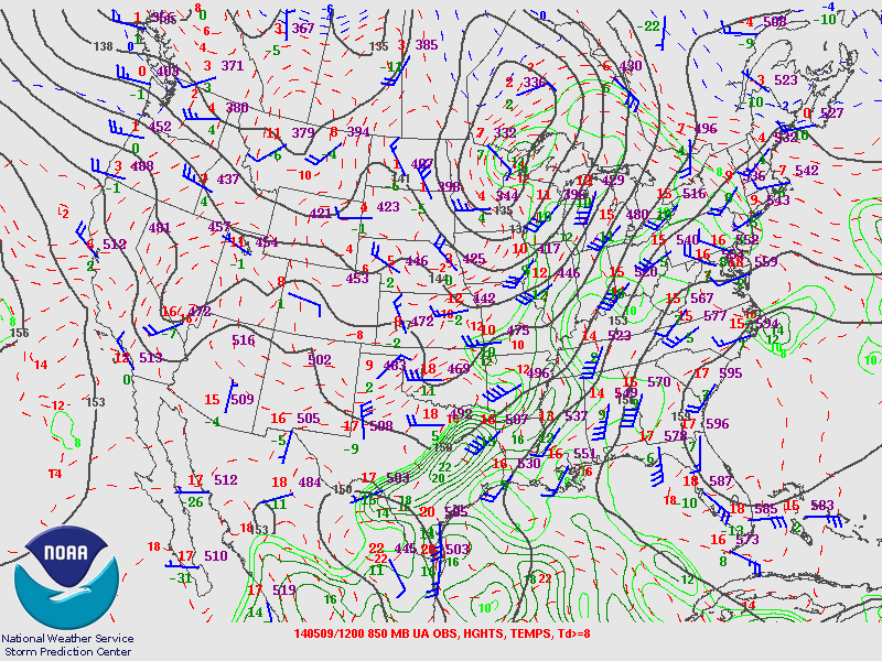
Moisture extends upward into the middle layers of the atmosphere providing more fuel for storm development. Additionally, light winds in the mid levels kept tornado potential relatively low.
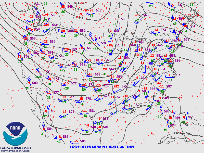
An upper level trough is noted through the middle part of the country. This trough was the focus for upper level energy needed to produce strong thunderstorms.
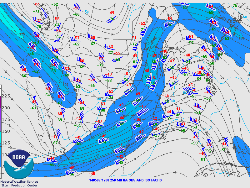
A strong upper level jet was approaching the area to provide upper level divergence.
Here is the Corpus Christi sounding from Friday morning (click the image to enlarge). Note the very high precipitable water (PW) reading of 2.0 inches, along with the very low forecast convective inhibition (CINH).

Here is the Friday morning sounding from Del Rio, Texas (click the image to enlarge). You can see the very high instability, with high convective available potential energy (CAPE).

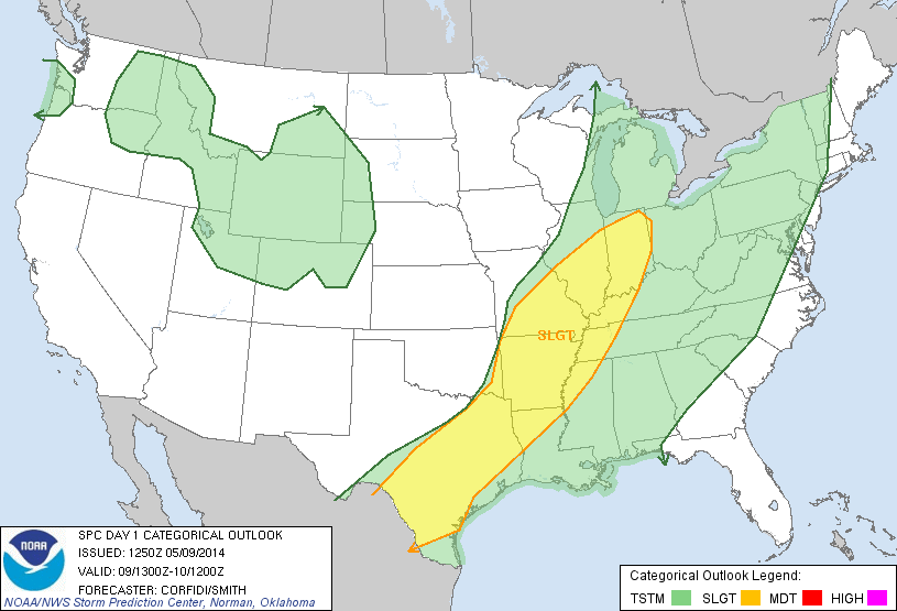
Here's Friday's outlook from the Storm Prediction Center.


 Follow us on YouTube