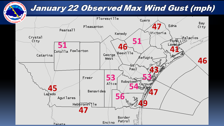
Strong winds developed over South Texas the night of January 21st through the daytime of January 22nd after the passage of a cold front. The surface low associated with the front was unusually deep this far south in the US and created a very strong pressure gradient over the region. Also, as daytime heating progressed, stronger winds several thousand feet off the surface mixed with the air near the surface, and increased wind speeds and wind gusts even more. The morning sounding at Corpus Christi showed a wind of 60 knots (69 mph) 3000 feet above the surface! As a result, winds gusted over 50 mph for some locations (mainly southeast portions of the Coastal Bend), while most of south Texas saw gusts greater than 40 mph.

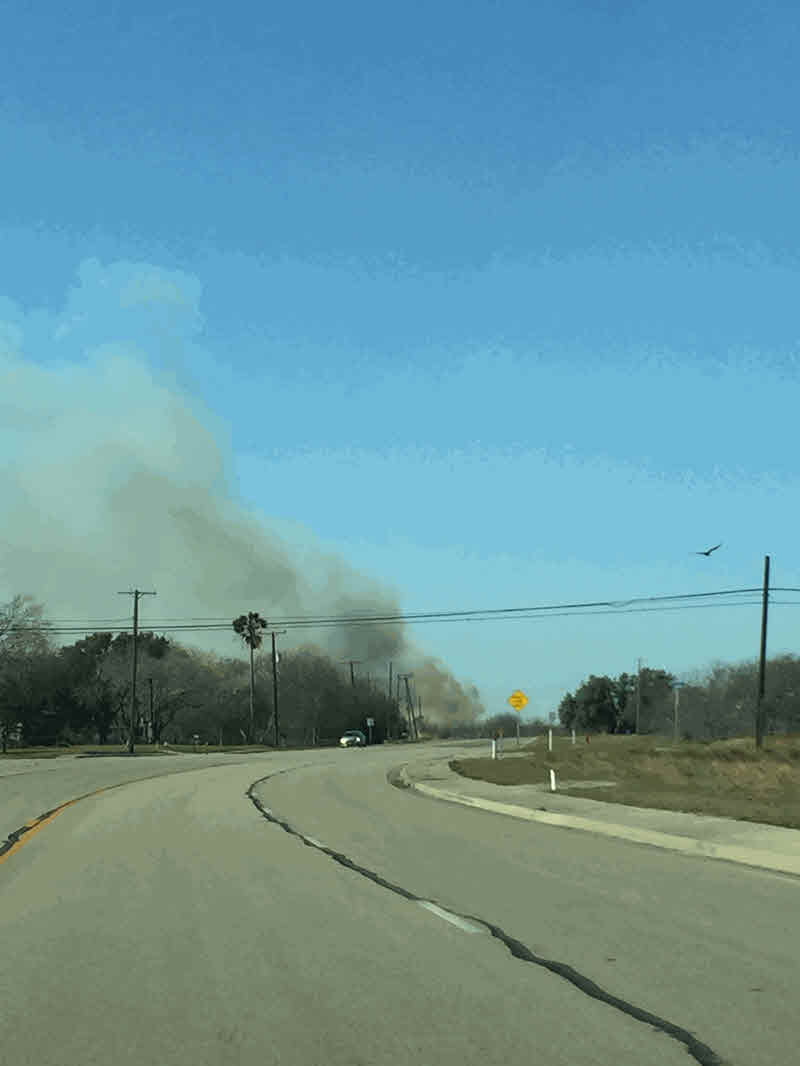
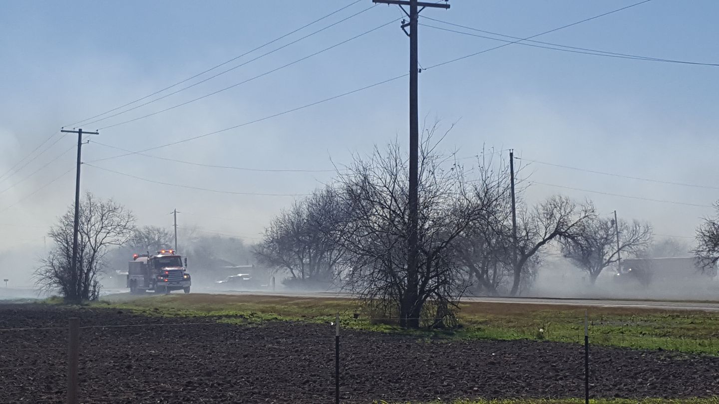
In addition to the strong winds across the area, the combination of the winds and extremely low relative humidity values created an extreme fire danger across the region. Numerous grass fires were reported across the region during the day.

Two other unusual impacts occurred as a result of the strong winds. The first being "blow out" of water along the western portions of bays and waterways along the coast. Low water levels were noted at several locations along the bays. Additionally, winds created a small seiche on lake Corpus Christi pushing water up against and over the Wesley Seale Dam. This picture is a side-by-side comparison from Violet Andrews Park in Portland, with a normal water level on the left and the water level observed on January 22nd on the right.

| Indian Point Park | Portland |
 |
 |
The water level trace just outside of the Wesley Seale Dam off of Lake Corpus Christi. The water level rose almost 6 feet through the morning and early afternoon before subsiding.

This wind event was well forecast by models and forecasters at the Corpus Christi forecast office, with the first mention of the potential for a wind advisory and red flag warning 5 days in advance of the event.
...24 Hour Peak Wind Gusts...

Location                     Speed     Time/Date       Provider

...Texas...

...Aransas County...
Aransas County Airport       44 MPH    0954 AM 01/22   ASOS
6 SSE Austwell               43 MPH    1159 AM 01/22   RAWS

...Bee County...
3 SW Beeville                46 MPH    1040 AM 01/22   AWOS

...Calhoun County...
14 ENE Fulton                42 MPH    0212 PM 01/22   RAWS
2 NW Seadrift                42 MPH    1106 AM 01/22   NOS-NWLON
Port Lavaca                  41 MPH    1015 AM 01/22   AWOS

...Jim Wells County...
Alice International Arpt     53 MPH    0103 PM 01/22   ASOS
Naval Auxilary Landing Field 52 MPH    0122 PM 01/22   ASOS

...Kleberg County...
Kingsville Nas               56 MPH    1024 AM 01/22   ASOS

...La Salle County...
Cotulla-lasalle County Airpo 51 MPH    0946 AM 01/22   ASOS

...Live Oak County...
2 N George West              41 MPH    0206 PM 01/22   RAWS

...Nueces County...
Corpus Christi               54 MPH    0939 AM 01/22   ASOS
Robstown                     49 MPH    0935 AM 01/22   AWOS
7 SE Aransas Pass            48 MPH    1000 AM 01/22   NOS-NWLON
3 S Flour Bluff              48 MPH    1007 AM 01/22   WXFLOW
1 SE Flour Bluff             46 MPH    0936 AM 01/22   WXFLOW
Port Aransas                 41 MPH    1255 PM 01/22   AWOS
Corpus Christi Nas           39 MPH    1046 PM 01/21   ASOS

...San Patricio County...
4 NNW Ingleside              53 MPH    1115 AM 01/22   AWOS

...Victoria County...
Regional Airport             47 MPH    1011 AM 01/22   ASOS
4 ENE Victoria               40 MPH    0104 PM 01/22   RAWS

...Webb County...
1 NE Laredo                  45 MPH    0145 PM 01/22   AWOS

...Maritime Stations...

5 SE Flour Bluff                            51 MPH    1007 AM 01/22
18 E Loyola Beach                           49 MPH    0936 AM 01/22
7 SE Flour Bluff                            48 MPH    1006 AM 01/22
Bob Hall Pier                               47 MPH    1012 AM 01/22
3 WNW Corpus Christi                        45 MPH    0930 AM 01/22
Mustang Island 85a                          44 MPH    0435 AM 01/22
8 SE Aransas Pass                           43 MPH    1200 PM 01/22
Portland                                    42 MPH    1230 PM 01/22
3 WNW Corpus Christi                        40 MPH    0435 AM 01/22
5 SE Flour Bluff                            38 MPH    0447 AM 01/22
4 ESE Flour Bluff                           38 MPH    0412 AM 01/22
10 SE Chapman Ranch                         30 MPH    0412 AM 01/22
10 SE Chapman Ranch                         30 MPH    0412 AM 01/22

Observations are collected from a variety of sources with varying
equipment and exposures. Not all data listed are considered official.
NWUS54 KCRP 230410
LSRCRP

PRELIMINARY LOCAL STORM REPORT...SUMMARY
NATIONAL WEATHER SERVICE CORPUS CHRISTI TX
1010 PM CST SUN JAN 22 2017

..TIME...   ...EVENT...      ...CITY LOCATION...     ...LAT.LON...
..DATE...   ....MAG....      ..COUNTY LOCATION..ST.. ...SOURCE....
            ..REMARKS..

1000 AM     NON-TSTM WND DMG 2 SW CORPUS CHRISTI     27.73N  97.45W
01/22/2017                   NUECES             TX   BROADCAST MEDIA

            REPORTS OF DOWNED POWERLINES. CAUSED SMALL GRASS FIRE.

1231 PM     WILDFIRE         4 WNW PORTLAND          27.90N  97.39W
01/22/2017  E5 ACRE          SAN PATRICIO       TX   NWS EMPLOYEE

            GRASSFIRE IN OPEN FIELD

1248 PM     SEICHE           4 SSW MATHIS            28.04N  97.85W
01/22/2017                   SAN PATRICIO       TX   CITY OFFICIAL

            WIND CAUSING SPILLOVER AT WESLEY SEALE DAM OF AROUND
            825 CFS

1257 PM     WILDFIRE         4 NE REFUGIO            28.35N  97.23W
01/22/2017  E96 ACRE         REFUGIO            TX   FOREST SERVICE

            TFS REPORTS AN ESTIMATED 96 ACRE WILDFIRE OCCURRED
            EARLIER TODAY

0130 PM     WILDFIRE         1 S SINTON              28.02N  97.51W
01/22/2017  E5 ACRE          SAN PATRICIO       TX   PUBLIC

0400 PM     WILDFIRE         ALICE                   27.76N  98.07W
01/22/2017  E100 ACRE        JIM WELLS          TX   DEPT OF HIGHWAYS

            UPDATE...TFS ESTIMATES FIRE TO BE 100 ACRES.
            PREVIOUS...FIRE IN FIELD NEAR COUNTY FAIRGROUNDS ON
            SOUTH...SOUTHWEST SIDE OF CITY HAS FORCED EVACUATIONS OF
            SEVERAL RESIDENCES

0749 PM     WILDFIRE         1 SSE ST. PAUL          28.09N  97.55W
01/22/2017  E50 ACRE         SAN PATRICIO       TX   FOREST SERVICE

            TFS REPORTS ESTIMATED 50 ACRE WILDIRE NEAR HWY 181 NEAR
            ST PAUL. 0 PERCENT CONTAINED AS OF WRITING
Infrared Satellite and 500mb Height 
US Surface Chart, 6am Jan 22, 2017 
South Central US Surface Chart, 6am Jan 22, 2017 
| 925 MB - 12Z 01/22/17 | 850 MB - 12Z 01/22/17 |
|---|---|
 |
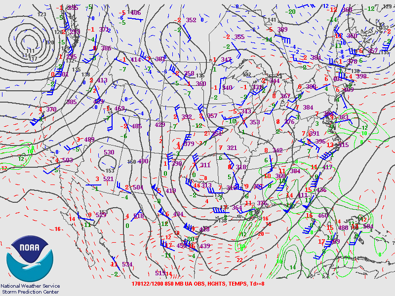 |
| 700 MB - 12Z 01/22/17 | 500 MB - 12Z 01/22/17 |
 |
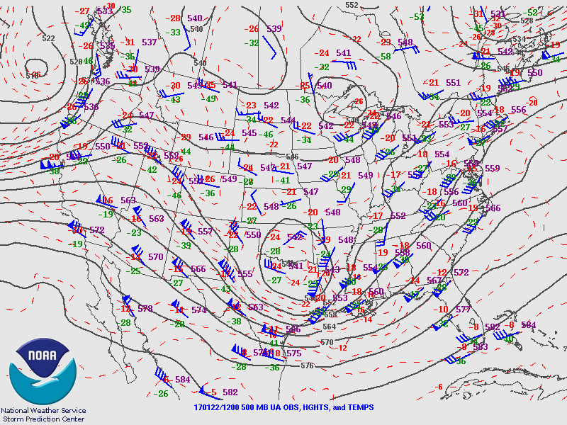 |
| KCRP SKEWT - 12Z 01/22/2017 | KCRP SKEWT - 00Z 01/23/2017 |
 |
 |


 Follow us on YouTube